vendredi 29 juin 2012

Digital map of Tokyo for the Tokyo Skytree

Posted by rod - 14.06.2012


On the 22nd of May the Tokyo Skytree opened its doors making it Japans highest structure. The innovative guys from Team Lab designed a digital map (mural) of Tokyo which was exhibited at the Skytree.

“Tokyo has no particular hero or heroines. Each one of us and our stories are creating the excitement of Tokyo. In Japanese art, there are works that includes vast amount of information without center, but with flat viewpoint that focusing on everything even stories of people. For example, Rakuchu Rakugai-zu( Scenes In and Around Kyoto) and Edo-zu Byobu(Edo Scenes Folding Screen)

We draw Tokyo as a flat, no-center city with full of information in details, by restructuring the means of drawing for Ukiyoe(Color print of everyday life in Edo Period) and other print works, that are famous in Edo period, with current technology.

In Tokyo, it becomes harder to distinguish things that physically exist from virtual things that are created and existing in Manga(comics) and animations.

If we take a look at the traditional Japanese art work called Hyakkiyakou(Night Parade of One Hundred Demons), it is predictable that may be Japan was originally the country with such environment(mix real things and virtual things) in earlier age.Thank to appearance of internet, people’s imagination explodes and it started to overflow into Tokyo, and finally started to change the reality.

Evolution of technology can also evolve the progress of human beings. Based on this conviction, this is an art work drawing a city changing from Edo to Tokyo, and to the future, with large amount of information that beyond the limits of human being.”

http://creativeroots.org/2012/06/digital-map-of-tokyo-for-the-tokyo-skytree/?utm_source=feedburner&utm_medium=feed&utm_campaign=Feed%3A+creativeroots+%28Art+and+design+inspiration+from+around+the+world%29

jeudi 28 juin 2012

Center Pivot Irrigation Explained

If you have been in a plane over a large agricultural hub you may have casually glanced out of your window. And then you may have performed a very, very quick double take. What on earth are those circular shapes below? They are not the alien crop circles of infamy that’s for sure – in fact whole fields seem to be circular in shape. There are way too many of them, too, to have been done as some sort of practical joke. So, what are they? Welcome to the world of center pivot irrigation.

Image Credit Flickr User Tresijas
Image Credit Flickr User SkySchemer
As the name suggests, this is a method of irrigation, but it is one which, after the initial setup, does not need the touch of human hand half as much as traditional methods. Imagine the middle of a field and place a great big pivot at its heart. To this pivot attach sprinklers and equipment to rotate them. As the pivot turns, so do the sprinklers – in a circular motion (the system is also called circle irrigation). The explanation is as simple as that, even if sometimes the patterns are not wholly circular -some can look like part of a giant Pacman game.

Image Credit Flickr User Soil Science
Image Credit Flickr User Patrick Huber
When do you think it started? Although it did not take off on a truly industrial scale until later the credit for this remarkable method of irrigation goes to a 1940s Texan farmer, Frank Zybach. His farm could be found near the town of Dalhart, which had the misfortune of being smack bang in the middle of the very dry Texas panhandle. It was vital that the distribution of water to the fields be improved upon and this solution is what Mr Zybach came up with in 1949.

Image Credit Wikimedia
Image Credit Flickr User uteart
Image Credit Flickr User Gardener31
They are quite simply spectacular. Yet to elucidate further we need to go from a bird’s eye view to that of a scarecrow. Ironically, given the ubiquity of air travel, many more people get to see them from great heights than on the ground. So, here they are.

Image Credit Flickr User BrewBooks
Image Credit Flickr User foto3166

Segments of aluminum or galvanized steel pipe (the number varies according to manufacturer) are connected together and supported by a system of trusses. They are then mounted upon wheeled towers – with sprinklers along their length. The role of the pivot is, not to put too fine a point on it, pivotal.

Image Credit Flickr User lostinfog
Image Credit Flickr User Carlpenergy

The picture above shows the pivot and the squat thing below is the water pump which feeds it. The water is fed through to the sprinklers and the whole leviathan is then set in motion. The motion is slow, to say the least – if you wanted to capture a single cycle through stop motion you would have to be patient – it normally takes around three days to complete an entire circle. The idea is to irrigate, after all, not to drown!

Image Credit Flickr User BrewBooks
Image Credit Flickr User USDA Gov

It is the sets of wheels on the periphery which set the pace. Modern technology plays its part. Sensors are placed on the segments which detect if and when they are losing alignment and this keeps all of the pieces perfectly straight. Without them a slight bend could turn in to a steel bending catastrophe.

Image Credit Flickr User USDAgov
Image Credit Wikimedia
Image Credit Flickr User Robert Love Taylor

As such the entire length of a center pivot rarely exceeds 1600 feet (around 500 meters) and the most common is around a quarter of a mile in diameter. You may be wondering why the water at the center of the field is not much wetter than that along its radius as the inner towers do not travel as far as those on the outside. The answer is, again, simple. The nozzles which spray the water are smaller on the inside than those farther out, so ensuring that water is delivered equally to all areas of the field.

Image Credit Flickr User Brykmantra
Image Credit Flickr User Sam Beebe Ecotrust
Image Credit Wikimedia
From satellites to planes, the patterns which are created fascinate and intrigue. Yet all this would not be possible without one vital if humble component- the sprinkler nozzle. They are crucial to the success of the center pivot irrigation system and many different types have been developed over the years by bespoke manufacturers. Nowadays, as you can see here, most nozzles are suspended from a pipe called a gooseneckmeaning they can be positioned just a few feet above the crop. As evaporation and wind could divert a lot of water otherwise, this proximity is imperative in arid areas.

Image Credit Flickr User BrewBooks
The water can even be dropped straight on the ground using a LEPA (which is a Low Energy Precision Application), involving a mini damming process which is very high tech and a twenty first century innovation. It must be said that since its invention in 1949 the center pivot system has come a long way. Back in Mr Zybach’s time this type of irrigation was water powered, eventually replaced by hydraulic systems. Today most systems have an electric motor on each of the towers.

Image Credit Flickr User M Gifford
Image Credit Flickr User WireLizard

For obvious reasons you cannot put this sort of irrigation system on a steep hill. However, although the ground has to be fairly flat, it can undulate. The machinery can cope with small ripples in the ground which beforehand had been difficult to farm. As you can see from these pictures, some nooks and crannies which were previous very difficult to farm can now yield crops. Farmland can now extend right up to where hills abruptly begin.

Image Credit Flickr User FutureAtlas
Image Credit Flickr User Olly Boyo

In parts of the Middle East and Africa it has been a huge success, conserving water which would otherwise have been wasted. And yet... of course there is a downside. As with any mechanization, fewer people are needed to produce the same amount of goods. Yet bear in mind that without center pivot irrigation the crop may never have been planted in the first place let alone become a harvest. However, many environmentalists are also concerned that with previously inaccessible areas now being farmed, whole ecosystems may be destroyed. Above, previously untouched ecosystems in the Sahara Desert in Libya and on the island of Madagascar are given the center pivot treatment.

Image Credit Flickr User Soil Science
Image Credit Flickr User Sam Beebe Ecotrust
So next time you are in a plane, peering down to the earth below and you see a strange collection of circles, you know exactly what they are and how they were created. You may even feel a sudden desire to tap the stranger next to you and bore them for a while with your wisdom!
Image Credit Flickr User dsearls

Acknowledgements
Kuriositas would like to thank the following Flickr Photographers for their kind permission to use their images:Tresijas, Sky Schemer, Patrick Huber, Robert Love Taylor and Ute Hagen. Please visit their amazing photostreams by clicking the links.

http://www.kuriositas.com/2012/06/center-pivot-irrigation-explained.html?utm_source=feedburner&utm_medium=feed&utm_campaign=Feed%3A+Kuriositas+%28Kuriositas%29

mercredi 27 juin 2012

Farmstar, N-Sensor, GPN, quand les nouvelles technologies se mettent au service de l’agriculture


Le programme s’appelle Farmstar. Développé par Astrium, une filiale d’EADS, il utilise les données des satellites.

Farmstar permet, grâce à un ordinateur préprogrammé, équipé d’un GPS et relié au semoir ou au pulvérisateur, de semer plus ou moins dense ou de répandre plus ou moins d’engrais et de produits phytosanitaires en fonction des caractéristiques du champ.

En France, 12 000 céréaliers utilisent déjà ce programme sur une superficie de 620 000 hectares (60%pour le blé, 30% pour le colza, et 10 pour l’orge d’hiver, précise Le Monde). Résultat ce sont 100 000 tonnes d’azote qui auraient été économisées en 10 ans.


« On table sur une économie moyenne de 10 à 20 euros par hectare sur les engrais, déduction faite du coût du service, qui est de 10 euros par hectare et par an, soit des revenus qui augmentent de 5 % en moyenne », déclare au Monde, Henri Douche, chef de marché agriculture chez Astrium, la filiale espace d’EADS qui développe ce service depuis 2002, en partenariat avec l’Institut du végétal Arvalis.

D’autres solutions existent. Avec les systèmes N-Sensor et GPN, mis au point par des fabricants d’engrais, l’analyse des plants se fait, non de l’espace, mais directement au sol : des capteurs optiques, fixés sur les tracteurs, mesurent, par exemple, en temps réel les taux de photosynthèse des plantes.

Coût prohibitif

Cette nouvelle forme d’agriculture à base d’informatique embarquée concerne tous les secteurs, de l’horticulture, à l’élevage laitier en passant par les vignobles. Sur iPhone il existe même une application qui permet de diagnostiquer les maladies des plantes afin de procéder au traitement curatif le plus ciblé possible.


Le but final c’est l’aide à la décision explique au Monde Christian Huygues, directeur scientifique adjoint du secteur agriculture de l’Institut national de la recherche agronomique (INRA).

« Ces outils délivrent en permanence des informations à l’agriculteur et lui permettent de passer un cap dans l’organisation de son exploitation, en s’éloignant des conseils classiques des coopératives. Plus l’exploitation est grande, plus les frais sont amortis rapidement ».

Seul véritable frein à l’expansion de cette « agriculture de précision », son coût, souvent prohibitif pour les plus petites exploitations.

Par Philippe CROUZILLACQ le juin 8th, 2012 

Combien de temps faut-il pour construire un gratte-ciel?

Regardez cette vidéo et dites ce que vous en pensez.


Une entreprise chinoise de construction appelée Broad Sustainable Building (BSB) a construit un immeuble de 30 étages en seulement 15 jours.

La vidéo montre comment ils pourraient réussir dans leur prochain projet : ils veulent construire le bâtiment le plus haut du monde en 90 jours.

Une fois terminé, le bâtiment préfabriqué serait de 838 mètres. C'est plus de 10 mètres plus haut que Dubaï Burj Khalifa, le plus haut bâtiment du monde actuel. Il a fallu environ 5 ans pour construire le Burj Khalifa.

via Kottke.

http://thekidshouldseethis.com/post/25552163884?utm_source=feedburner&utm_medium=feed&utm_campaign=Feed%3A+TheKidShouldSeeThis+%28The+Kid+Should+See+This.%29 

11 belles et intéressantes passerelles autour du Monde

A footbridge or pedestrian bridge is a bridge designed for pedestrians and in some cases cyclists, animal traffic and horse riders, rather than vehicular traffic. Footbridges complement the landscape and can be used decoratively to visually link two distinct areas or to signal a transaction. In many developed countries, footbridges are both functional and can be beautiful works of art and sculpture.

1. BP Pedestrian Bridge, Illinois, USA


link
The BP Pedestrian Bridge, or simply BP Bridge, is a girder footbridge in the Loop community area of Chicago, Illinois, United States. This pedestrian bridge serves as a noise barrier for traffic sounds from Columbus Drive. It is a connecting link between Millennium Park and destinations to the east, such as the nearby lakefront, other parts of Grant Park and a parking garage.


link
BP Bridge uses a concealed box girder design with a concrete base, and its deck is covered by hardwood floor boards. It is designed without handrails, using stainless steel parapets instead. The total length is 935 feet (285 m), with a five percent slope on its inclined surfaces that makes it barrier free and accessible. Although the bridge is closed in winter because ice cannot be safely removed from its wooden walkway, it has received favorable reviews for its design and aesthetics. [link, map]


2. Capilano Suspension Bridge, Canada


link
The Capilano Suspension Bridge is Vancouver’s oldest tourist attraction, having been built in 1889. The current bridge is 450 feet (137m) across and 230 feet (70m) above the river. The Capilano Suspension Bridge and Park draws over 800,000 visitors a year. It offers splendid views of the river below and old growth forest. Experiencing the thrill of Vancouver's largest suspension bridge is a must for any local or visitor.


link
The bridge was originally built in 1889 by George Grant Mackay, a Scottish civil engineer and park commissioner for Vancouver. It was originally made of hemp ropes with a deck of cedar planks, and was replaced with a wire cable bridge in 1903. MacEachran purchased the Bridge from Mahon in 1935 and invited local natives to place their totem poles in the park, adding a native theme. In 1945, he sold the bridge to Henri Aubeneau. The bridge was completely rebuilt in 1956. [link, map]

3. Shaharah Bridge, Yemen


link
The Shaharah Bridge, Yemen, build to fight turkish invaders. The legend says that the local people can remove the bridge in few minutes in case of imminent danger.


link
This 17th century bridge was built to connect towns at the tops of mountains in the country of Yemen. It’s another scary bridge and a popular attraction with tourists, but the local residents still cross it regularly as a part of their daily routine. Shaharah bridge spans 300 meters (990 ft) deep gorge. [link]

4. Old Bridge, Bosnia and Herzegovina


link
Old Bridge (Stari Most) is a reconstruction of a 16th century Ottoman bridge in the city of Mostar, Bosnia and Herzegovina that crosses the river Neretva and connects two parts of the city.


link
The Old Bridge stood for 427 years, until it was destroyed on November 9, 1993 by Bosnian Croat forces during the Croat-Bosniak War. Subsequently, a project was set in motion to reconstruct it, and the rebuilt bridge opened in 2004. [link, map]

5. Trift Bridge, Switzerland


link
Trift Bridge is one of the most spectacular pedestrian suspension bridges of the Alps. It is 100 meters (330 ft) high and 170 meters (569 ft) long, and is poised above the region of the Trift Glacier. Even reaching the bridge through the ravine by cable car is an adventure.


link
The bridge spans the lake, Triftsee, near Gadmen, Switzerland in an area that receives approximately 20,000 visitors per year to see the Trift Glacier. An earlier bridge was built in 2004. A replacement bridge was opened on June 12, 2009. It was completed in only six weeks. [link1, link2, map]

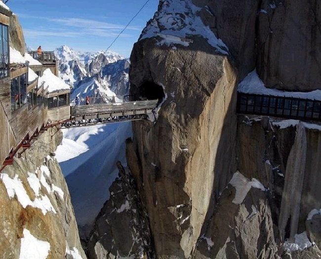
6. Aiguille du Midi Bridge, France


link
Built in the French Alps it represents an observation deck. In short, it’s a tiny bridge between two cliffs that connects two mountains and offers a marvelous view of the Mont Blanc massif.


link
The bridge is rather broad and firm, but the height (12,605 feet or 3.850 m above sea level) at which it is located, is terrifying. In line with that, the bridge is a real and unforgettable adventure for extreme lovers. [link]

7. Marienbrücke Bridge, Germany


link
Marienbrücke (Mary's Bridge) is a bridge located near the famous Neuschwanstein castlein Hohenschwangau, Bavaria. Many tourists each year visit the bridge to get a good view of the castle, and take pictures of themselves with it in the background. The bridge crosses a large gorge, with steep cliffs on both sides. Underneath runs a water fall from the surrounding mountains down into the valley.


link
The bridge itself is about 30 minutes walk away from the town of Hohenschwangau. The bridge can be crossed, and with a bit more walking up steep terrain, another famous lookout point for the castle can be reached. [link, map]

8. Puente de la Mujer, Argentina


link
Puente de la Mujer is a rotating footbridge for Dock 3 of the Puerto Madero commercial district of Buenos Aires, Argentina. It is of the Cantilever spar cable-stayed bridge type and is also a swing bridge, but somewhat unusual in its asymmetrical arrangement.


link
It has a single mast with cables suspending a portion of the bridge which rotates 90 degrees in order to allow water traffic to pass. When it swings to allow watercraft passage, the far end comes to a resting point on a stabilizing pylon. [link, map]

9. Rialto Bridge, Italy


link
Rialto Bridge is one oldest of the four bridges spanning the Grand Canal (Venice). The first crossing over the Canal was a pontoon bridge built in 1181. Thanks to the development of the Rialto Market the traffic on the bridge increased and by 1255 it was replaced by a wooden bridge. During the early 15th century, shops were built along the sides of the bridge which insured the money for maintenance (because of the taxes paid by shop owners).


link
It partially caught fire in 1310, while in 1444 it collapsed under the weight of the crowd watching a boat parade. It collapsed again in 1524. The present stone bridge was completed in 1591. On either side of the bridge there are rows of shops. [link, map]

10. Kingsgate Bridge, UK


link
Kingsgate Bridge is a striking, modern reinforced concrete construction footbridge across the River Wear, in Durham, England. It is a Grade I listed building. It was designed in 1963 by Sir Ove Arup personally, connecting Bow Lane on the historic peninsula in the centre of Durham to Dunelm House on New Elvet (to which building Arup's studio also contributed), and opened in 1966.


link
Kingsgate Bridge is thought to have been one of Arup's favourite designs of all, he having spent many hours working on every detail of the plans. Its construction was unusual. The two halves were each built parallel to the river, then rotated through 90° to make the crossing. [link, map]

11. Jade Belt Bridge, China


link
The Jade Belt Bridge, also known as the Camel's Back Bridge, is an 18th century pedestrian Moon bridge located on the grounds of the Summer Palace in Beijing, China. It is famous for its distinctive tall thin single arch.


link
The Jade Belt Bridge is the most well-known of the six bridges on the western shore ofKunming Lake. It was erected in the years 1751 to 1764, during the reign of the Qianlong Emperor, and was built in the style of the delicate bridges in the country-side of southern China. It is made from marble and other white stone. [link, map]

Bonus: Footbridge Out of Order - The Old Bridge of Konitsa, Greece


link
The old bridge of Konitsa over the river Aoos, one of the highest of its kind in Greece. Behind this bridge starts the Vikos-Aoos National Park. In winter, the river bed is completely covered with water.


link
Under the bridge, a bell can be seen; local villagers say that when the wind is strong enough to make the bell produce sound. It is too dangerous to cross the bridge. [link]

http://www.theworldgeography.com/2012/06/11-beautiful-interesting-footbridges.html