Affichage des articles dont le libellé est Atmosphère. Afficher tous les articles

lundi 16 septembre 2013

Hunting Earth's Mystery Lightning From the International Space Station


A Red Sprite taken from the ISS, via Wikimedia

For astronauts aboard the International Space Station, the view of the Earth isn’t just space age eye candy. It’s a unique perspective from which they can shed light on nagging questions about our home planet. It’s a perspective scientists exploit by sending remote experiments to the station in their stead, experiments like Firestation, which is designed to study the obscure side of a phenomenon we’re all pretty familiar with: lightning.


The lightning we all know and love (or hate, perhaps) is those jagged columns of light that heat the air to 50,000°F as they plunge from electrically charged clouds towards the Earth. But lightning doesn’t exclusively move down towards Earth from clouds. Lightning in the upper atmosphere can also move up from storm clouds into space.

It’s only recently that scientists discovered the strange lightning-related phenomena happening in the tops of clouds. There are red sprites, blue jets, and elves, cold forms of lightning that shoot upwards from storm clouds. There are strange jets of antimatter that also fly upwards, triggering the detectors on NASA's orbiting high-energy observatories. There are even gamma ray bursts that happen as often as 500 times a day during which Earth briefly mimics a supernova. These are known, appropriately, as Terrestrial Gamma-ray Flashes or TGFs.

Scientists know these phenomena exist, but no one is entirely sure how they relate to the lightning on the lower half of the cloud that we see during a thunderstorm. Hopefully this will change soon, thanks to Firestation, a package of sensors designed to explore the links between TGFs, ordinary lightning, and sprites.

Firestation’s principal investigator Doug Rowland from NASA's Goddard Space Flight Center calls the ISS the perfect platform from which to explore these cloud-top lightning phenomena. During the experiment’s one year lifetime, the ISS will carry the bevy of sensors over thousands of active thunderstorms. He hopes that from this vantage point, Firestation will see up to 50 lightning strikes per day and at least one TGF every few hours.


A diagram showing the relative heights of various forms of lightning. via

With each storm, Firestation will gather plenty of data. Unlike previous upper atmospheric lightning experiments, it has the unique ability to observe thunderstorms in multiple wavelengths at the same time. In one go the detector can record radio static from lightning; measure the optical glow of lightning, red sprites, and blu elves; and detect gamma-rays and electrons associated with TGFs and any other antimatter events.

The TGFs are of particular interest. Right now, scientists don’t know for sure which type of lightning produces the surprisingly high-energy gamma-ray flashes they’ve seen. Gamma-rays are thought to come from the hottest and violent places in the universe, so their appearance at the top of our planet’s cold atmosphere is quite a surprise. Something up there is accelerating low-energy particles of air to nearly the speed of light to produce this gamma-radiation and the occasional burst of antimatter. Scientists want to know what this “something” is, and Firestation is going to unlock the mystery.

After gathering data from so many types of phenomena across so many wavelengths, researchers should be able to sort out the cause-and-effect connections between these lighting events.

Firestation was delivered to the ISS on Aug. 3, 2013, by the Japanese robotic cargo vessel Kounotori-4. It’s already been installed on the station’s exterior and the sensors have been checked out. All that’s left is to start the experiment, which is slated to happen this month. Once Firestation is up and running, scientists expect it will be only a matter of weeks before the biggest mysteries of upper atmospheric lightning are answered, adding these phenomena to the list of questions answered thanks to the space age.

By Amy Teitel 18 hours ago

samedi 7 septembre 2013

Une sonde vers la lune pour étudier sa fine atmosphère

On ignorait il y a 40 ans que la Lune avait une atmosphère. Reporters/SPL

La NASA a lancé avec succès une nouvelle sonde vers la Lune pour percer les secrets de sa fine atmosphère. Minotaur V

Quarante ans après que les derniers astronautes du programme Apollo eurent quitté le sol lunaire, la NASA a lancé avec succès tard vendredi une nouvelle sonde vers la Lune pour percer les secrets de sa fine atmosphère.

Cette mission devrait aussi aider à mieux comprendre d’autres objets du système solaire comme les gros astéroïdes ou la planète Mercure.

La fusée Minotaur V à cinq étages, un missile intercontinental reconverti, s’est arrachée de son pas de tir sur le centre spatial de Wallops situé sur une île près des côtes de Virginie (sud-est) comme prévu à 23H27 locales (3H27 GMT) sous un ciel étoilé.

Le vaisseau non habité qu’elle transporte, de la taille d’une petite voiture, appelé «Lunar Atmosphere and Dust Environment Explorer» (LADEE), s’est séparé du dernier étage de Minautor V quelque 20 minutes après le lancement. La sonde devrait atteindre l’orbite lunaire dans un mois.

Poussière

Doté de trois instruments scientifiques dont deux spectromètres, LADEE qui pèse 383 kilos dont 135 kg de carburant, doit récolter des données détaillées sur la structure et la composition chimique de l’atmosphère lunaire très ténue (1/100.000é la densité de celle de la Terre) et déterminer si de la poussière y reste en suspension surtout près du sol.

Des grains de poussière pourraient expliquer le mystère des lueurs observées par les astronautes d’Apollo entre 1969 et 1972 à l’horizon lunaire juste avant le lever du soleil, précise la NASA.

Une meilleure compréhension des caractéristiques de l’atmosphère de notre plus proche voisin céleste pourrait aider les scientifiques à comprendre d’autres objets de notre système solaire comme les grands astéroïdes ou les autres lunes tournant autour d’autres planètes, estiment les responsables de cette mission de 280 millions de dollars initiée en 2008.

«Nous avons étudié la Lune de façon très étendue depuis que les derniers astronautes d’Apollo ont quitté le sol lunaire il y a 40 ans quand nous pensions qu’elle était dépourvue d’atmosphère», a commenté la veille lors d’une conférence de presse John Grunsfeld, administrateur adjoint de la NASA responsable des programmes scientifiques.

«Grâce à des orbiteurs de reconnaissance, nous avons découvert que ce satellite naturel de la Terre était scientifiquement beaucoup plus intéressant et qu’il avait une espèce d’atmosphère», a-t-il poursuivi. Pour lui, cette mission «pourrait aider à mieux comprendre la diversité de notre système solaire et son évolution».

Avant exploration

Mais étudier l’atmosphère lunaire doit se faire sans attendre avant que des missions d’exploration ne viennent perturber cet environnement fragile, a expliqué Sarah Noble, une scientifique du programme LADEE. En effet, son atmosphère est tellement fine et fragile que l’alunissage d’un engin pourrait l’affecter, prévient-elle.

Plusieurs pays dont surtout la Chine ont indiqué leur intention d’aller sur la lune. Pékin a annoncé la semaine dernière le lancement d’un atterrisseur lunaire d’ici la fin 2014.

«Je pense que l’atmosphère de la Lune n’est pas la première priorité de la mission mais plutôt la poussière qui pourrait être en suspension au-dessus du sol et peut poser des problèmes pour les équipements dans le cadre de missions lunaires habitées de longue durée», dit à l’AFP John Logsdon, ancien directeur du «Space Policy Institute» à Washington.

LADEE restera d’abord 40 jours très haut au-dessus de la surface lunaire pour effectuer une série de tests. Elle utilisera notamment une nouvelle technologie laser de transmission aussi puissante que celle des réseaux de fibres optiques terrestres. Ensuite elle entamera sa mission d’étude scientifique de l’atmosphère lunaire durant 100 jours.

La mission la plus récente de la NASA vers la Lune remonte à 2012 avec le lancement des deux sondes jumelles GRAIL pour percer les secrets de l’intérieur lunaire et mesurer le champ de gravitation.

Depuis Apollo, sur les quelque 40 missions américaines vers la Lune, LADEE sera la seconde sonde lunaire à ne pas être lancée de Cap Canaveral en Floride. La première, Clementine, avait été lancée en 1994 de Californie.

Le centre spatial de Wallops est à 270 kilomètres de la capitale américaine. Créé en 1945, il a été longtemps utilisé pour lancer de petits engins suborbitaux et des ballons scientifiques.

Source: afp

dimanche 25 août 2013

Layers of the atmosphere


The Earth is surrounded by the atmosphere, which is the body of air or gasses that protects the planet and enables life. Most of our atmosphere is located close to the earth’s surface where it is most dense. The air of our planet is 79% nitrogen and just under 21% oxygen; the small amount remaining is composed of carbon dioxide and other gasses. There are five distinct layers of the earth. Let’s look at each, from closest to farthest from the earth…

Troposphere:

The layer of the atmosphere closest to the earth is the troposphere. This layer is where weather occurs. It begins at the surface of the earth and extends out to about 4-12 miles. The temperature of the troposphere decreases with height. This layer is known as the lower atmosphere.

Stratosphere:

Above the troposphere is the stratosphere, which extends to about 30-35 miles above the earth’s surface. Temperature rises within the stratosphere but still remains well below freezing.

Mesosphere:

From about 35 to 50 miles above the surface of the earth lies the mesosphere, where the air is especially thin and molecules are great distances apart. Temperatures in the mesosphere reach a low of -184°F (-120°C). The stratosphere and the mesosphere are the middle atmosphere.

Thermosphere:

The thermosphere rises several hundred miles above the earth’s surface, from 50 miles up to about 400 miles. Temperature increases with height and can rise to as high as 3,600°F (2000°C). Nonetheless, the air would feel cold because the hot molecules are so far apart. This layer is known as the upper atmosphere.

Exosphere:

Extending from the top of the thermosphere to 6200 miles (10,000 km) above the earth is the exosphere. This layer has very few atmospheric molecules, which can escape into space.

Pauses:

Between each layer of the atmosphere is a boundary. Above the troposphere is the tropopause; above the stratosphere is the stratopause; above the mesosphere is the mesopause; and above the thermosphere is the thermopause. At these “pauses,” maximum change between the “spheres” occur.

Image source

Posted on August 23, 2013

Reblogged from: Terra Mater

http://science-junkie.tumblr.com/

dimanche 18 août 2013

Almost orbital, solar-powered drone offered as “atmospheric satellite”

Titan's Solara, first commercial solar drone, can fly five years without landing.


A model of the Solara 50, Titan Aerospace's commercial "atmospheric satellite," hangs above the company's booth at the AUVSI Unmanned Systems conference booth.


WASHINGTON—At the AUVSI Unmanned Systems conference, New Mexico-based startup Titan Aerospace unveiled the company's prototypes for "atmospheric satellites"—autonomous unmanned aircraft powered purely by solar energy and capable of staying aloft at high altitude for up to five years. The first commercially manufactured long-endurance solar drone, the Solara 50, is under construction now and is expected to fly next year. A bigger drone, the Solara 60, will soon follow.

While solar-powered flight has been a reality since the early 1980s, Titan is the first company to work on commercially manufacturing solar-powered drones. And unlike some of the prototypes that have been flown by the established players in the aerospace and unmanned systems field, the Solara drones are based on well-worn technologies and simplicity in design.

If successful, Titan could change the economics of businesses that have previously depended on low-orbit satellites and allow for a persistent coverage closer to what satellites in geostationary orbit provide.

On the wings of a penguin

Solar-powered flight has been a reality since AeroVironment took the lessons from the human-powered aircraft Gossamer Albatross—which flew across the English Channel in 1979—and applied them in the Gossamer Penguin and Solar Challenger aircraft in the early 1980s. But complexity and durability issues have dogged most efforts to create the holy grail of solar aircraft—a drone that can stay aloft indefinitely.

AeroVironment has built a number of solar-powered aircraft for the government, including the Helios prototype—a giant drone with a wingspan of 247 feet powered by solar panels and hydrogen fuel cells. The Helios crashed off of Hawaii in 2003 when it suffered structural failure due to turbulence.

The early success of Helios partially inspired the Defense Advanced Research Projects Agency (DARPA) and Boeing's "Vulture" program in 2008, an effort to create a drone that could spend up to five years on station at 60,000 to 90,000 feet with a thousand-pound payload. Qinetq's Zephyr, one of the program's competitors, flew for 336 hours and 22 minutes, setting the endurance record for unmanned aircraft—but it set the record after DARPA cut the funding for the Boeing contract and reduced the program's scope to work on solar cells and energy storage systems.

That didn't end the Defense Department's appetite for long-flying drones. But the alternative paths chosen so far haven’t paid off. Another AeroVironment aircraft, the Global Observer—a purely hydrogen-powered drone with a 70-foot wingspan designed for week-long missions—crashed in 2011, resulting in the termination of the program by the Pentagon. Boeing has its own hydrogen-powered, long-endurance drone, the Phantom Eye, in development; so far its longest flight has been just over two hours.


A model of Boeing's Phantom Eye at Boeing's AUVSA conference booth.

Almost orbital

Titan's aircraft plans are more modest and much more ambitious at the same time. Solara 50 will have a payload of just 70 pounds—though depending on the time of year and location of the flight, longer daylight hours could sustain flights with heavier payloads. The next design, the Solara 60, will carry up to 250 pounds. Instead of using hydrogen fuel cells, the Solara aircraft use batteries charged from solar panels to power flight at night and provide about 100 watts of power to the aircraft's payload as well.

The Solara 50 has a 50 m (164 feet) wingspan. The upper surfaces of its wings and tail are packed with over 3,000 photovoltaic cells capable of generating up to 7 kilowatts. It is launched by catapult and can land (when it has to) by skidding on its Kevlar-coated underside. Unlike the giant flying-wing configurations of the Helios and Zephyr, which had large numbers of propellers, the Solara has a single, high-efficiency motor.

In theory, a solar-powered drone capable of withstanding long flights at high altitude—in what Titan executives call the "sweet spot" in the Earth's atmosphere between 60,000 and 70,000 feet, above nearly all weather patterns in a zone where winds are typically less than 5 knots (5.75 miles/hour)—would be able to perform tasks usually reserved for satellites at a much lower cost.

For example, during a presentation by Titan at AVUSA, a company spokesperson compared using a satellite for multispectral Earth imagery—say, like Landsat's—to using an atmospheric satellite. A drone could be put up quickly, for much less initial capital. At the same time, it would provide targeted imagery at a cost of less than $5 per square kilometer—versus $35 per square kilometer from a satellite—while still offering the large area of coverage of a satellite.


Enlarge / Artist's rendering of Solara 50 at high altitude.
Titan Aerospace
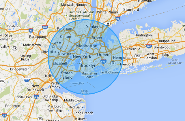
Enlarge / The coverage area of a Solara 50, superimposed over New York.

As a communications relay, the Solara offers about an 18-mile radius of coverage—easily covering all of New York City's five boroughs, as shown in the map above. A "constellation" of Solara craft could create a persistent communication network for disaster relief efforts or could provide long-term services, such as Google's planned air-based broadband in areas without existing telecommunications infrastructure. The search giant is planning to deploy Solara drones as part of the Internet Africa Project.

Titan already has customer reservations for the first three of its Solara drones, two of which are intended to serve as communications relays (though the customer has not been identified). The first will be delivered in February, with manufacturing ramping up for monthly delivery starting in April.

by Sean Gallagher - Aug 18 2013, 8:00pm PM

dimanche 26 mai 2013

Atmospheric Remote Sensing: Modeled PM2.5

Atmospheric remote sensing can be used to measure levels of some air pollutants. Remote sensing data come from satellites. These data can be used in combination with other data to help us better understand when and where air pollution is happening. This is important because air pollution can cause health problems. Knowing more about when and where air pollution is happening can help public health officials and others do more to protect our health. Read more about the health problems related to air pollution here.

Although atmospheric remote sensing data can help estimate air pollution levels, these data have limitations especially if used on their own. Satellite data are not always available. For example, it is nearly impossible to collect satellite data on a cloudy day. Clouds can interfere with the satellite's ability to collect data which can cause a gap in the information that comes from them. This is one reason why atmospheric remote sensing data should be used in addition to monitoring and modeled air data.Compliance with air pollution standards usually is measured through the use of EPA's Air Quality System monitors. These monitors are on the ground and are placed around the country, mainly in large cities. Data from these monitoring stations are considered the "gold standard" for determining outdoor air pollution. However, this information is limited because the monitoring stations are usually near big cities and may take air samples only every three days or during periods when air pollution is very high. Read more about air monitoring here. Using remote sensing data from satellites can help fill in the gaps that exist from air monitors on the ground.

The National Aeronautics and Space Administration (NASA) provides atmospheric sensing data from their satellites for this project. Scientists from CDC, NASA, and Emory University are working together to determine how these data can be used with other air pollution monitoring data to measure fine particulate matter in outdoor air. Fine particulate matter is also called PM2.5. Read more about PM2.5 here.

The Tracking Network is now providing estimates of annual average PM2.5 concentrations using remote sensing data. Currently, data are available only for Alabama, Georgia, and parts of South Carolina, Tennessee, North Carolina, Florida, and Virginia. This project is still evolving, but we are sharing the progress we have made.

Annual PM2.5 Level (Remote Sensing Data)

This indicator provides county-level information on the annual average level of PM2.5 using atmospheric remote sensing data. These data can be used to show trends in PM2.5 over time. This information can be used with other air pollution estimates to understand more about when and where people are exposed to PM2.5. The file below includes annual remote sensing PM2.5predictions using two different sources of weather data.
  • Remote sensing data using North American Regional Reanalysis (NARR)
  • Remote sensing data using North American Land Data Assimilation Systems (NLDAS)

mardi 13 septembre 2011

Un satellite va se servir du système GPS pour sonder l'atmosphère

Thales Alenia Space vient de livrer le sondeur atmosphérique du satellite environnemental Megha-Tropiques. Lancé le 25 septembre prochain par un lanceur indien, il utilisera les signaux GPS pour étudier .

Thales Alenia Space a livré à l’Agence spatiale indienne (Isro) l’instrument Rosa (Radio Occultation Sounder for the Atmosphere) qui doit être monté sur le satellite franco-indien Megha-Tropiques destiné à étudier le cycle de l'eau dans l'atmosphère dans la zone tropicale.

L’objectif de Megha-Tropiques est d'améliorer nos connaissances sur la contribution du cycle de l'eau à la dynamique du climat dans l'atmosphère tropicale. Pour cela, il est doté de trois instruments, développés par le Cnes pour l’un et en partenariat avec l’Isro pour les deux autres.

L’instrument livré par Thales Alenia Space est déjà embarqué sur deux autres satellites. Il vole sur le satellite indien Oceansat 2, lancé en septembre 2009 et l’argentin Sac-D de la Conae (Comisión Nacional de Actividades Espaciales), lancé en juin 2011. Seules quelques petites modifications sont apportées pour qu’il s’intègre au mieux à la plateforme du satellite. Il est identique à celui qui vole sur Sac-D et n'a qu'une seule antenne, au lieu de deux sur celui monté sur Oceansat 2.


Humidité de la troposphère et électrons de l"ionosphère
Rosa utilise les signaux du système GPS comme des sondages radio. Il capte les émissions de ces satellites au moment où ils se trouvent, pour lui, au ras de l'atmosphère. Le détecteur Rosa analyse la phase de ces signaux et envoie l'information sur Terre. Le déphasage avec les mêmes signaux GPS reçus au sol, et qui ont donc traversé la troposphère, permet d'estimer le température, la pression et l'humidité de l'air. Dans le domaine de la météorologie, l'analyse de ces données permet de repérer les perturbations et leurs déplacements. Elle permet aussi d'étudier l'ionosphère, cette couche ionisée de la haute atmosphère, en cartographiant les densités d'électrons libres. On peut ainsi prévoir les tempêtes magnétiques.

Le satellite Megha-Tropiques sera lancé le 25 septembre 2011 par la fusée indienne PSLV depuis le centre spatial de Satish Dawan, dans l’île de Sriharikota, au large des côtes de l'État d'Andra-Pradesh, à l'est de l'Inde.

Par Rémy Decourt, Futura-Sciences

Le 13 septembre 2011 à 08h32

http://www.futura-sciences.com/fr/news/t/astronautique/d/un-satellite-va-se-servir-du-systeme-gps-pour-sonder-latmosphere_33344/#xtor=RSS-8