rached-innov

rached-innov : Innovation, Science, Espace, Politique

Affichage des articles dont le libellé est Drones. Afficher tous les articles

jeudi 9 octobre 2014

Les utilisations civiles des drones

Les drones m’intéressent et me fascinent. Je n’en possède pas et je ne les utilise pas encore. Je n’en suis pas technologiquement spécialiste. Cependant, je peux traiter et analyser les images acquises par des caméras embarquées à bord de drones. C’est le genre de technologie qui va se développer considérablement dans les années prochaines. Leur utilisation va se diversifier et va toucher toutes les catégories humaines, et même les animaux. Comme c'est souvent le cas quand il s'agit de technologies en évolution rapide, la loi a du mal à faire face à la montée en popularité des véhicules aériens sans pilote (UAV). Dans [1], on évoque la tentative de quelques poids lourds de l’industrie qui se sont associés pour constituer la Small UAV Coalition afin d’ouvrir la voie à un usage commercial, philanthropique et civil de petits drones aux États-Unis et dans le monde. Le groupe cherche également à soutenir l'utilisation récréative des petits drones par les amateurs. L'objectif principal de la coalition est de développer un processus réglementaire ouvert qui assure "une exploitation sûre, fiable et opportune des petits drones." Elle fait également pression pour des changements de réglementation afin que les petits drones puissent être exploités au-delà de la ligne de vue avec des degrés divers d'autonomie. Le groupe classe les petits drones dans la catégorie de ceux qui pèsent moins de 25 kg et qui volent généralement à une altitude de moins de 122 m au-dessus du niveau du sol. Ces petits drones sont également alimentés par des batteries rechargeables et peuvent être pilotés manuellement via une télécommande ou de manière autonome en utilisant un programme automatisé se trouvant à bord. Ils peuvent procurer des avantages considérables aux consommateurs de tant de manières passionnantes et pratiques. Cependant, pour en profiter en toute légalité, il faudrait réglementer leur utilisation notamment en ce qui concerne les fréquences de communication utilisés et les questions de vie privée.


Photo: Shutterstock publiée dans [1]

La livraison par drones

Les petits drones peuvent être utilisés dans quasiment tous les domaines ayant une relation avec le géospatial, tels que la photo aérienne, la topographie et la cartographie, l'agriculture de précision, la livraison de produits aux consommateurs, la gestion des catastrophes, le journalisme, et la surveillance. Je vais en présenter quelques exemples qui viennent d’être évoqués pendant cette semaine sur plusieurs sites. Bien sûr, je ne traiterai que les applications civiles. Les militaires ne les utilisent que pour tuer ou faire de la reconnaissance à l’instar de l’information donnée par [2] qui indique que le commandement de l'armée libanaise a annoncé, dans un communiqué, la violation de l'espace aérien libanais, mardi, par deux drones de reconnaissance israéliens. Parmi les applications civiles, on trouve celle publiée sur les deux sites [3] et [4], qui concerne les livraisons de colis avec des drones. C'est DHL en Allemagne qui vient d'obtenir une première véritable autorisation de vol commercial ! DHL vient d'obtenir l'autorisation de livrer des colis par drone au nord-ouest de l'Allemagne et plus précisément sur l'Île de Juist. Les habitants de cette île sont parfois un peu coupés du monde et ont besoin d'être ravitaillés rapidement en médicaments ou autres colis urgents. Le drone de DHL a été baptisé Parcelcopter 2.0. Il s'agit d'un quadricopter capable de voler à une altitude de 50 mètres et à la vitesse de 65 km/h durant 45 minutes avec une charge de 1,2 Kg. Durant le vol, un opérateur sera en charge de surveiller à distance si tout se passe bien et sera même autorisé à prendre le contrôle de l'appareil en cas de problème. C'est une véritable bonne nouvelle que de pouvoir utiliser les drones pour livrer des zones éloignées sans avoir besoin d'affréter un hélicoptère ou un avion beaucoup plus cher. Voir la vidéo.


La deuxième utilisation vient de paraître dans [5] et [6] qui indique que la FAA ("Federal Aviation Administration") aux Etats-Unis allait autoriser six entreprises de production audiovisuelle à recourir à des drones sur le territoire américain. Cette décision est un premier pas vers le développement généralisé des drones au sein de la puissante industrie du film et de la télévision. Jusqu'à présent, les drones étaient bannis des tournages aux Etats-Unis, un pays qui a interdit l'usage des drones à des fins commerciales en 2007. La décision de la FAA marque donc un revirement notable. On s'oriente vers un élargissement des autorisations d'utilisation de drones à des fins commerciales aux Etats-Unis : un marché potentiellement très important...

En plus de cette information, on aussi dans parle [6] du PlexiDrone qui est un drone dont les pièces peuvent être assemblées et préparés pour le vol en une minute. Il dispose d'un support sur ​​sa face inférieure pour attacher une caméra vidéo. Sa monture est personnalisable et peut prendre en charge n'importe quel appareil photo de moins de 1 kg. Le PlexiDrone est piloté avec un appareil mobile iOS ou Android et possède un train d'atterrissage rétractable. Il est muni d’un GPS qui permet d’utiliser le drone pour vous suivre par derrière comme quand on fait du ski, du snowboard, du vélo ou du jogging. La batterie 5000 mAh fournit un temps de vol entre 15 et 35 minutes, tandis que la portée s'étend à 1000 m. Le PlexiDrone arbore également un capteur à l'avant conçu pour détecter des objets dans une proximité de 3 m pour aider à prévenir les collisions. Voir la vidéo.


L'observation des volcans par drones

La troisième utilisation est dans l’observation des volcans [7]. Une équipe de vidéographes a récemment envoyé un drone muni d'une caméra GoPro pour visiter l’éruption actuelle de la fissure Holuhraun au sommet du volcan islandais Bardarbunga. Les résultats sont étonnants et excessivement rares, avec des images en gros plan de bouillonnement et d’explosion du magma. Il faisait si chaud que la caméra (qui vaut 1000 dollars) a fondu et heureusement que la carte micro SD ait survécu pour pouvoir récupérer ces images spectaculaires d’un volcan en éruption.

Pour promouvoir l’utilisation des drones à des fins civiles, le site [8] informe de la tenue, le 10 octobre 2014, au Parc d'Activités Alpespace en France, des 1ères Rencontres Interprofessionnelles Drones en Rhône-Alpes. 200 à 300 participants sont attendus à ce rendez-vous inédit auquel vont participer les professionnels du secteur que sont les fabricants, les prestataires et les télé-pilotes, mais aussi les institutions, les collectivités et les entreprises qui utilisent déjà ces engins révolutionnaires ou qui souhaitent découvrir les solutions qu'offrent ces derniers dans un contexte civil. Des conférences débats vont présenter les drones, l’état des lieux et la législation française et européenne dans ce domaine, ainsi que leurs utilisations actuelles et les perspectives d'évolution. Il y aura aussi des démonstrations de drones et des mises en situation.


Références
[1] Small UAV Coalition formed to promote civil and commercial use of small UAVs. Publié le 2 octobre 2014.
http://www.gizmag.com/small-uav-coalition/34097/?utm_source=Gizmag+Subscribers&utm_campaign=e261f995f7-UA-2235360-4&utm_medium=email&utm_term=0_65b67362bd-e261f995f7-91181277

[2] Des drones sionistes dans le ciel de Liban. Publié le mercredi 01 octobre 2014. 
http://french.irib.ir/info/moyen-orient/item/342980-deux-drones-isra%C3%A9liens-ont-viol%C3%A9-l-espace-a%C3%A9rien-du-liban

[3] La livraison par drone arrive en Allemagne par DHL. Publié le 30 septembre 2014. 
http://hitek.fr/actualite/dhl-livraison-drone_3874  

[4] Ultra-Portable Camera Robot that You can Swarm. Publié le 26 septembre 2014.
http://www.gizmag.com/dhl-parcelcopter-delivery-drone/34001/?utm_source=Gizmag+Subscribers&utm_campaign=8451209e38-UA-2235360-4&utm_medium=email&utm_term=0_65b67362bd-8451209e38-91181277

[5] Les drones arrivent sur les tournages américains. Publié le 3 octobre 2014. 
http://www.bulletins-electroniques.com/actualites/76851.htm

[6] Modular PlexiDrone homes in on aerial photography.  Publié le 2 octobre 2014. 
http://www.gizmag.com/modular-plexidrone-aerial-photography/34095/?utm_source=Gizmag+Subscribers&utm_campaign=e261f995f7-UA-2235360-4&utm_medium=email&utm_term=0_65b67362bd-e261f995f7-91181277

[7] Drone with GoPro camera films closeup of Iceland volcano. Publié le 3 octobre 2014.
http://www.terradaily.com/reports/Drone_with_GoPro_camera_films_closeup_of_Iceland_volcano_999.html

[8] 1ères Rencontres Interprofessionnelles Drones en Rhône-Alpes. Publié le 7 octobre 2014. 
http://www.bulletins-electroniques.com/actualites/76878.htm


Publié par Unknown à 23:42 0 commentaires
Envoyer par e-mailBlogThis!Partager sur XPartager sur FacebookPartager sur Pinterest
Libellés : Cinéma, Drones, Livraison, réglementation, UAV, Volcans

vendredi 19 septembre 2014

Des drones équipés de lasers cartographient les sites mayas


Les drones sont envisagés dans de nombreux usages tous très différents. Aujourd’hui, ils se rendent même utiles aux archéologues, qui les équipent de lasers pour mieux cartographier les sites mayas qu’ils découvrent.

Ces drones commandés à distance sont donc capables de survoler une zone précise, et de capturer des images et toutes sortes de données d’un site depuis le ciel afin de le reconstituer en 3D.

Ils ont ainsi reconstitué une partie du site de El Zotz, en Méso-Amérique, et peuvent ainsi l’étudier sous tous les angles. Et ils ne comptent pas s’arrêter là, puisqu’ils annoncent leur volonté d’utiliser cette technologie dans de nouvelles zones, et ainsi de pouvoir obtenir des reproductions 3D de forêts entières, même malgré l’obstacle représenté par les arbres.

Par Nicolas Aguila19 SEPTEMBRE 2014 09:30 - Source: Tom's Guide FR

http://www.tomsguide.fr/actualite/drone-3d-maya,44913.html#xtor=RSS-201
Publié par Unknown à 14:48 0 commentaires
Envoyer par e-mailBlogThis!Partager sur XPartager sur FacebookPartager sur Pinterest
Libellés : Archéologie, cartographie, Drones, Informatique, laser

jeudi 28 août 2014

Présent et futur des drones civils


L'utilisation des drones civils connaît un essor important. Pour le simple plaisir ou pour la prise de clichés et de vidéos via des angles jusque-là impossibles sans utiliser un hélicoptère, ces appareils peuvent séduire les technophiles. La promesse est d'ailleurs attirante, pouvoir manier aisément un engin aux caractéristiques intéressantes en utilisant de simples commandes, un smartphone ou même, pour quelques prototypes, des Google Glass.

De ce fait, les drones sont l’un des domaines les plus dynamiques de l’aviation civile. Le nombre d’exploitants croît rapidement en Europe (plus de 1500 fin 2013).

Ce « jeune » secteur aéronautique est en train de se développer au profit des utilisateurs de ces nouveaux systèmes. Il concerne presque tout le monde : le monde industriel, les organismes de recherche, les services publics et les autorités responsables des réglementations mais également tous ceux qui s’intéressent aux questions sociétales posées par les nouvelles activités engendrées par les drones.

Plusieurs types de drones civils sont aujourd'hui disponibles à des prix variant de 1000 à 10000 dinars (de 500 à 5000 euros).

Ils répondent à de nombreuses exigences de la société et de l'économie. Le marché potentiel est des plus promettants. Ils sont dotés de capacité de filmer et de monter des vidéos de leur vol qui intéressent plusieurs secteurs d'activités socio-économique. Cependant, ils sont aussi à l'origine de nombreuses préoccupations : sécurité, sûreté, environnement et vie privée.  

Comment favoriser le développement de ce domaine dans notre pays et pour quels types d'usages ? Comment la réglementation puisse-t-elle suivre cet engouement envers les drones ?

Publié par Unknown à 10:23 0 commentaires
Envoyer par e-mailBlogThis!Partager sur XPartager sur FacebookPartager sur Pinterest
Libellés : Drones, Futur

samedi 23 août 2014

Drones: The Future of Filmmaking


http://visual.ly/drones-future-filmmaking-0
Publié par Unknown à 12:42 0 commentaires
Envoyer par e-mailBlogThis!Partager sur XPartager sur FacebookPartager sur Pinterest
Libellés : Drones, Fimsmaking

dimanche 17 août 2014

Drones civils : quelle réglementation ?


© Helibird

L'utilisation des drones civils connaît un essor important. Pour le simple plaisir ou pour la prise de clichés et de vidéos sans utiliser un hélicoptère, ces engins séduisent énormément surtout en période estivale.

A LIRE AUSSI ►►► L'explosion du marché des drones civils

La pratique est toutefois encadrée sur notre territoire. L'arrêté du 11 avril 2012 relatif à la " conception des aéronefs civils qui circulent sans aucune personne à bord, aux conditions de leur emploi et sur les capacités requises des personnes qui les utilisent " précise ainsi ce qu'il est possible de faire en France pour ces drones (hors ballons sondes, fusées, cerfs-volants).

►►► Les drones de catégorie A

Le législateur introduit ainsi plusieurs catégories d'appareils volants. Pour un engin non doté d'une caméra et pesant moins de 25 Kg, les règles restent encore plutôt permissives puisque pour la grande majorité des appareils vendus pour le loisir (catégorie A), les textes obligent simplement à ce que le drone reste en vue directe. Cela signifie que l'appareil et son conducteur devront rester en contact visuel et ne pas voler plus haut qu'une altitude de 150 mètres ou à proximité d'une zone dangereuse ou interdite.

►►► Une réglementation plus stricte pour filmer avec son drone

Si le drone est muni d'un moyen de filmer ou de prendre des clichés, la réglementation se fait plus stricte. La loi n'opère pas de distinction entre usage personnel et professionnel et précise qu'en fonction de la zone survolée, des autorisations préfectorales doivent être demandées. C'est par exemple le cas pour des vols se déroulant en agglomération ou à proximité de personnes ou d'animaux, en vue directe et à une distance horizontale maximale de 100 mètres du pilote.


►►► Faire voler un drone hors vue directe, c'est possible à condition d'avoir une autorisation et d'informer le ministère chargé de l'aviation civile

Si le possesseur d'un drone souhaite faire un vol hors vue directe et en dehors d'une zone peuplée, il devra également obtenir une autorisation au plus tard, 24h avant un vol et informer le ministère chargé de l'aviation civile par e-mail. Il ne peut pas non plus voler seul puisque les textes obligent à ce qu'une seconde personne (le pilote principal) assiste le pilote en immersion. Le " second " doit alors être en mesure de prendre à tout moment le contrôle de l'appareil. Aussi, la loi précise que le pilote ne peut pas faire évoluer un aéronef télé piloté s'il est lui-même à bord d'un autre véhicule en déplacement. Une telle opération reste néanmoins possible sur autorisation du ministre chargé de l'aviation civile.

►►► Pour plus d'informations vous pouvez écouter la version longue de l'interview :
DRONES VERSION LONGUE 16/02 - CHRONIQUES DU CIEL
  • play
  • mute
00:00
17:31
CHRONIQUES DU CIEL par Frédéric Beniada dimanche 17 août 2014
http://www.franceinfo.fr/emission/chroniques-du-ciel/2014-ete/drones-civils-quelle-reglementation-08-17-2014-07-50
Publié par Unknown à 14:18 0 commentaires
Envoyer par e-mailBlogThis!Partager sur XPartager sur FacebookPartager sur Pinterest
Libellés : Civils, Drones, réglementation

jeudi 17 juillet 2014

Drones: Next big thing in aviation is small

An AeroVironment Puma AE, front, and Raven small unmanned
aircraft systems are displayed at the AeroVironment stand during
Farnborough International Air Show, Farnborough, England,
Tuesday, July 15, 2014. (AP Photo/Sang Tan)


The next big thing in aviation may be really small. With some no bigger than a hummingbird, the hottest things at this week's Farnborough International Airshow are tiny compared with the titans of the sky, such as the Airbus 380 or the Boeing Dreamliner.

What's got aviation geeks salivating at Farnborough, this year's biggest aviation jamboree that features participants from 40 countries, are the commercial possibilities of unmanned aerial vehicles - drones to most of us.

Drones are more commonly known for their use in conflict areas. This week Hamas launched for the first time an unmanned drone into Israeli airspace that was shot down.

But drones, which can weigh less than an ounce, have potential commercial applications that are vast. The industry, military and non-military, is growing and could according to some see investments of nearly $90 billion over the next ten years.

Experts say they can be adapted to fly over fields to determine when crops need watering, fly into clouds in hopes of offering more precise predictions on twisters, track endangered rhinos, spot wildfires and search out vast stretches of land for missing children.

And like the dawn of the era of aviation a little over a century ago, innovations are often being conducted by individuals with an idea and endless enthusiasm. They won't find it easy though as the big players in the markets, such as Boeing and Airbus, are also getting involved.

A lot of the research has been taking place in big flat places such as the Plains States, where a broad expanse of land combines with universities near military bases with air space exclusions to make research possible.

Where California had Silicon Valley to drive its high-tech industries, America's central belt from North Dakota to Texas could become a new research and commercial center for the aviation industry - the Silicon Plains.

"This is open country for entrepreneurs," said Stephen McKeever, Oklahoma's secretary of science and technology. "There will be a Steve Jobs."

But things are a bit on hold at the moment for the American makers of unmanned air vehicles, or UAVs, as they await rules from the Federal Aviation Administration. Under current rules, you can legally fly drones for "recreational purposes," as long as you comply with certain basic guidelines - such as keeping well clear of airports. ...


by Eugene Hoshiko
July 17, 2014

Read more at: http://phys.org/news/2014-07-drones-big-aviation-small.html#jCp
Publié par Unknown à 09:58 0 commentaires
Envoyer par e-mailBlogThis!Partager sur XPartager sur FacebookPartager sur Pinterest
Libellés : Drones

lundi 30 septembre 2013

Transformer un aspirateur en drone


Les ingénieurs de Dyson s’ennuient parfois. Le constructeur britannique s’est alors lancé un défi : construire un drone, un appareil volant, à l’aide uniquement de pièce détachée de la marque. Mission accomplie, par plus de 100 ingénieurs qui ont proposé leurs visions des objets volants, concoctés uniquement à partir d’élément initialement conçus pour des… aspirateurs. Plusieurs épreuves ont été mises en place pour éprouver les capacités des objets volants, qui s’en sortent pour certains mieux que d’autres.

La vidéo ci-dessous illustre ce concours, avec de véritables OVNIS : avions à ailettes orientables, quadricopter à faire pâlir l’AR.Drone de Parrot, etc. D’ailleurs, la marque n’exclut pas que ces projets se concrétisent un jour, laissant imaginer tout et n’importe quoi de la part des amateurs d’objets volants.


Dyson engineers build flying machines


Par Maximilien de Léséleuc30 SEPTEMBRE 2013 17:00 - Source: Tom's Guide FR

http://www.tomsguide.fr/actualite/dyson-aspirateur-drone,22729.html#xtor=RSS-201
Publié par Unknown à 22:14 0 commentaires
Envoyer par e-mailBlogThis!Partager sur XPartager sur FacebookPartager sur Pinterest
Libellés : Drones

samedi 28 septembre 2013

Un drone du MIT joue les guides touristiques sur le campus


L’utilisation des drones n’est plus limitée à des fins militaires. Après le drone livreur de pizza, voici un modèle qui officie comme un guide touristique personnel. Mis au point par l’équipe duSENSEable City Lab du MIT, il assiste les étudiants et les visiteurs pour trouver leur chemin dans le campus.

Batpisé SkyCall, le petit véhicule aérien sans pilote a été conçu pour être utile au quotidien. Encore à l’état de prototype, il s’agit d’un quadricoptère équipé d’un système de pilotage automatique, d’un appareil photo, d’un module Wi-Fi, d’un GPS et d’un tas de capteurs. Tout ceci lui permet de voler de façon autonome et de définir son emplacement. Grâce à une application pour smartphone, l’utilisateur peut l’appeler pour bénéficier de ses services. Le drone pourra le retrouver grâce aux coordonnées GPS. Comme chaque destination est traduite par un code, il suffit de saisir le code approprié pour que le drone vous conduise dans le bon chemin. L’utilisateur peut également le mettre en mode pause en cas de besoin. Pour éviter les obstacles, il utilise des capteurs sonars.

Les concepteurs de SkyCall travaillent actuellement sur les améliorations à apporter pour obtenir une version plus performante. D’ailleurs, ils envisagent d’autres modèles aux fonctionnalités avancées dans l’avenir.


Drone SkyCall du MIT


Par Anja François RANDRIAVANIAINA

28 SEPTEMBRE 2013 11:00 

Source: Tom's Guide FR

http://www.tomsguide.fr/actualite/drone-guide,22704.html#xtor=RSS-201
Publié par Unknown à 12:09 0 commentaires
Envoyer par e-mailBlogThis!Partager sur XPartager sur FacebookPartager sur Pinterest
Libellés : campus, Drones, Guide, MIT, Tourisme

mercredi 18 septembre 2013

Les drones du futur fonctionneront à l’énergie solaire


Plus d’autonomie en vol, pas de lourde batterie à transporter à bord de l’appareil : le pari du drone civil fonctionnant à l’énergie solaire semble prometteur. Le site web du magazine The Economist détaille les avantages de ce nouveau système.

Inspection des pipelines, vaporisation de pesticides sur de grandes exploitations agricoles… Le secteur du drone civil est en plein boom. Mais la plupart des missions que les entreprises voudraient confier à ces petits avions sans pilote leurs demandent une grande autonomie. Aujourd’hui, la plupart des appareils sont alimentés par des batteries électriques assez lourdes qui leur permettent de voler deux heures trente maximum.

Selon le magazine The Economist, le solaire devrait permettre d’augmenter nettement cette autonomie. Le Californien Kevin Jones développe avec l’entreprise SunPower un drone recouvert de cellules photovoltaïques, qui exploite les courants d’air chaud ascendants pour voler plus longtemps comme les planeurs. SunPower avait aussi participé à la conception de l’avion solaire Solar Impulse.

Ce système devrait à terme permettre au drone, baptisée TaLEUAS (pour Tactical Long Endurance Unmanned Aerial System), de voler de 200 à 300% plus longtemps que s’il était branché sur une batterie traditionnelle. L’autonomie était de 60% supérieure au cours des premiers essais effectués avec la machine.

Par Lélia de Matharel - Publié le 18 septembre 2013, à 12h19

http://www.usinenouvelle.com/article/les-drones-du-futur-fonctionneront-a-l-energie-solaire.N205162#xtor=RSS-215
Publié par Unknown à 12:40 0 commentaires
Envoyer par e-mailBlogThis!Partager sur XPartager sur FacebookPartager sur Pinterest
Libellés : Drones, Energie solaire

dimanche 15 septembre 2013

NASA sends drones to track hurricanes' secrets

A pair of converted military drones are the US space agency's newest tools for tracking hurricanes and tropical storms, with the aim of improving forecasters' ability to predict them.

Originally built for military reconnaissance missions around the world, they are the size of large commercial jets and are flown remotely from a NASA base on the Virginia coast.

The drones are capable of flying for 30 hours at an altitude of 21,000 meters (69,000 feet), or twice the height of a passenger plane.

They can also cover large swaths of the Pacific and Atlantic Oceans in a single mission, according to Chris Naftel, head of the drone project at NASA's Dryden center in California, the secondary drone base.

The two Global Hawks began operating as NASA drones in 2012, as part of a project that will last for three years. The drones operate in most active months—August and September—of the Atlantic hurricane season, which goes from June to the end of November.

"It opens a window into a storm we did not have before," said Scott Braun, a research meteorologist on the project called HS3, short for the Hurricane and Severe Storm Sentinel.

"Before we had short snap shots of individual storms at various times," he told AFP.

Until now, the old stand-bys for monitoring storms have been piloted weather planes and satellites, he said.

"By being able to view a storm continuously over a 20 hour period, you have a longer window to capture it," he added.

"This experiment will allow a better understanding of the processes that govern the intensification in the formation of storms."

Even though scientists have been able to make great leaps in projecting the paths of hurricanes in recent years, their ability to predict the power and severity of storms has improved very little.

Better forecasts would help authorities more swiftly make life and death decisions, like whether and when to evacuate people in the storm's path.

According to NASA, nearly 100 million Americans live within 80 kilometers (50 miles) of a coast and are therefore at risk of being in the path of a hurricane.

The drones have two chief scientific missions: to determine the role of thunderstorms and rain in the intensification of storms, and to study the influence of the Saharan Air Layer, in the intensity of tropical cyclones.

This very dry and dusty air mass forms over the Sahara desert and moves into the tropical Atlantic from the end of springtime until the beginning of autumn.

Scientists are divided about the air mass's impact on the intensity of tropical cyclones. Some think that the dry air could weaken a storm by blocking the upward motion of air and wind, while others suggest that the phenomenon makes storms more potent.

NASA along with the National Oceanic and Atmospheric Administration (NOAA) are partners in the 30 million dollar program, and they hope that the information collected during three hurricane seasons in the Atlantic will provide some answers.

Each of the planes is equipped with different instruments, including a laser for studying the structure of the clouds, a microwave system to probe the heart of hurricanes, GPS systems and radar. The drones' precision instruments measure temperature, humidity and atmospheric pressure several times per second.

"We are really interested in trying to get measurements as close as we can to the surface of the ocean," said NOAA scientist Gary Wick.

The data are transmitted to the drone, which sends them via satellite to the control tower at Wallops then to the National Hurricane Center in Miami, Florida where they can be redistributed to weather forecasters across the country in near real-time.

1 hour ago by Jean-Louis Santini

© 2013 AFP

http://phys.org/news/2013-09-nasa-drones-track-hurricanes-secrets.html
Publié par Unknown à 13:06 0 commentaires
Envoyer par e-mailBlogThis!Partager sur XPartager sur FacebookPartager sur Pinterest
Libellés : Drones, météo, NASA, Ouragon, secret

jeudi 12 septembre 2013

Meet the Drone That's Guiding New Students Around MIT This Fall


Navigating a new campus is all part of the nostalgic movie montage that is freshman year of college. The changing leaves! The quaint Gothic architecture! The... drone tour guide? That’s the concept behind Skycall, a playful prototype that's designed to help visiting Harvard students find their way around MIT’s notoriously confusing campus—which has been called "one of mankind’s most difficult and disorienting labyrinths."

Skycall is the work of the Senseable City Laboratory, an MIT research group that explores how sensor technology can be deployed to help make cities smarter. As the lab's director Carlo Ratti explained to me, the idea for Skycall came from a common sight on MIT’s campus (where Harvard students can take classes). “All these Harvard students are always getting lost at MIT,” he says. "If you’re not familiar with it, it’s very hard to navigate, and we wondered how we could give them a hand."


In theory, the Skycall quadcopter is equipped with all the hardware necessary to find, communicate with, and track the intended target… er, student. The UAV is summoned using a custom-built app that serves as Skycall’s nerve center. After finding the intended user with its onboard GPS system and camera, Skycall can speak with the student using its audio system and microphone. It’s also possible to pause the tour via the app, or even cut it short.

Skycall sounds like a marketing stunt, and in a way, it is—for the Senseable City Lab’s broader work with UAVs. For Ratti and his team, drones represent a valuable tool that's mainly been leveraged to do harm, both through warfare or surveillance. “Drones have been used for a lot of questionable activities recently,” Ratti says. “But they can also be very useful at the scale of the city.” For example, one upcoming Lab project will use UAVs to sample air and water quality around Boston. “They’re are a way to help us better understand our environment,” Ratti adds.

So while the prototype is more of a concept than a workable app, it’s a playful way to hint at how drones—a technology with a massively negative public image—could ultimately play a positive role in American cities. Though maybe not every American city.


KELSEY CAMPBELL-DOLLAGHAN

Yesterday 5:20pm

http://gizmodo.com/meet-the-drone-thats-guiding-new-students-around-mit-t-1294335491
Publié par Unknown à 08:25 0 commentaires
Envoyer par e-mailBlogThis!Partager sur XPartager sur FacebookPartager sur Pinterest
Libellés : Drones, Etudiants, Guide

jeudi 22 août 2013

Sky Drone Lets you see it in Digital HD


The Sky Drone folks have an Indiegogo campaign selling Sky Drone quadrotors equipped with a digital, HD first-person viewing (FPV) camera system that operates over 3G or 4G. One advantage of this technology versus regular old analog RC is that your range is limited only by local cell towers; the only ground equipment you need is a smartphone or tablet. The feed is encrypted as well.

If you look at the prototype (to the right) you can get a sense of how the system works. A BeagleBone Black controls a USB camera module and communicates with the smartphone with the help of a cellular modem.

By John Baichtal

Posted 08/22/2013 @ 5:00 am

http://makezine.com/2013/08/22/sky-drone-lets-you-see-it-in-digital-hd/
Publié par Unknown à 13:41 0 commentaires
Envoyer par e-mailBlogThis!Partager sur XPartager sur FacebookPartager sur Pinterest
Libellés : Digital, Drones, HD, Numérique

dimanche 18 août 2013

Almost orbital, solar-powered drone offered as “atmospheric satellite”

Titan's Solara, first commercial solar drone, can fly five years without landing.


A model of the Solara 50, Titan Aerospace's commercial "atmospheric satellite," hangs above the company's booth at the AUVSI Unmanned Systems conference booth.


WASHINGTON—At the AUVSI Unmanned Systems conference, New Mexico-based startup Titan Aerospace unveiled the company's prototypes for "atmospheric satellites"—autonomous unmanned aircraft powered purely by solar energy and capable of staying aloft at high altitude for up to five years. The first commercially manufactured long-endurance solar drone, the Solara 50, is under construction now and is expected to fly next year. A bigger drone, the Solara 60, will soon follow.

While solar-powered flight has been a reality since the early 1980s, Titan is the first company to work on commercially manufacturing solar-powered drones. And unlike some of the prototypes that have been flown by the established players in the aerospace and unmanned systems field, the Solara drones are based on well-worn technologies and simplicity in design.

If successful, Titan could change the economics of businesses that have previously depended on low-orbit satellites and allow for a persistent coverage closer to what satellites in geostationary orbit provide.

On the wings of a penguin

Solar-powered flight has been a reality since AeroVironment took the lessons from the human-powered aircraft Gossamer Albatross—which flew across the English Channel in 1979—and applied them in the Gossamer Penguin and Solar Challenger aircraft in the early 1980s. But complexity and durability issues have dogged most efforts to create the holy grail of solar aircraft—a drone that can stay aloft indefinitely.

AeroVironment has built a number of solar-powered aircraft for the government, including the Helios prototype—a giant drone with a wingspan of 247 feet powered by solar panels and hydrogen fuel cells. The Helios crashed off of Hawaii in 2003 when it suffered structural failure due to turbulence.

The early success of Helios partially inspired the Defense Advanced Research Projects Agency (DARPA) and Boeing's "Vulture" program in 2008, an effort to create a drone that could spend up to five years on station at 60,000 to 90,000 feet with a thousand-pound payload. Qinetq's Zephyr, one of the program's competitors, flew for 336 hours and 22 minutes, setting the endurance record for unmanned aircraft—but it set the record after DARPA cut the funding for the Boeing contract and reduced the program's scope to work on solar cells and energy storage systems.

That didn't end the Defense Department's appetite for long-flying drones. But the alternative paths chosen so far haven’t paid off. Another AeroVironment aircraft, the Global Observer—a purely hydrogen-powered drone with a 70-foot wingspan designed for week-long missions—crashed in 2011, resulting in the termination of the program by the Pentagon. Boeing has its own hydrogen-powered, long-endurance drone, the Phantom Eye, in development; so far its longest flight has been just over two hours.


A model of Boeing's Phantom Eye at Boeing's AUVSA conference booth.

Almost orbital

Titan's aircraft plans are more modest and much more ambitious at the same time. Solara 50 will have a payload of just 70 pounds—though depending on the time of year and location of the flight, longer daylight hours could sustain flights with heavier payloads. The next design, the Solara 60, will carry up to 250 pounds. Instead of using hydrogen fuel cells, the Solara aircraft use batteries charged from solar panels to power flight at night and provide about 100 watts of power to the aircraft's payload as well.

The Solara 50 has a 50 m (164 feet) wingspan. The upper surfaces of its wings and tail are packed with over 3,000 photovoltaic cells capable of generating up to 7 kilowatts. It is launched by catapult and can land (when it has to) by skidding on its Kevlar-coated underside. Unlike the giant flying-wing configurations of the Helios and Zephyr, which had large numbers of propellers, the Solara has a single, high-efficiency motor.

In theory, a solar-powered drone capable of withstanding long flights at high altitude—in what Titan executives call the "sweet spot" in the Earth's atmosphere between 60,000 and 70,000 feet, above nearly all weather patterns in a zone where winds are typically less than 5 knots (5.75 miles/hour)—would be able to perform tasks usually reserved for satellites at a much lower cost.

For example, during a presentation by Titan at AVUSA, a company spokesperson compared using a satellite for multispectral Earth imagery—say, like Landsat's—to using an atmospheric satellite. A drone could be put up quickly, for much less initial capital. At the same time, it would provide targeted imagery at a cost of less than $5 per square kilometer—versus $35 per square kilometer from a satellite—while still offering the large area of coverage of a satellite.


Enlarge / Artist's rendering of Solara 50 at high altitude.
Titan Aerospace
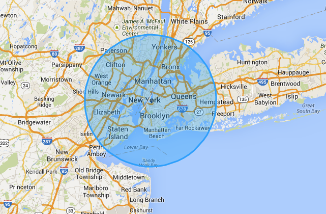
Enlarge / The coverage area of a Solara 50, superimposed over New York.

As a communications relay, the Solara offers about an 18-mile radius of coverage—easily covering all of New York City's five boroughs, as shown in the map above. A "constellation" of Solara craft could create a persistent communication network for disaster relief efforts or could provide long-term services, such as Google's planned air-based broadband in areas without existing telecommunications infrastructure. The search giant is planning to deploy Solara drones as part of the Internet Africa Project.

Titan already has customer reservations for the first three of its Solara drones, two of which are intended to serve as communications relays (though the customer has not been identified). The first will be delivered in February, with manufacturing ramping up for monthly delivery starting in April.

by Sean Gallagher - Aug 18 2013, 8:00pm PM

http://arstechnica.com/information-technology/2013/08/almost-orbital-solar-powered-drone-offered-as-atmospheric-satellite/
Publié par Unknown à 21:46 0 commentaires
Envoyer par e-mailBlogThis!Partager sur XPartager sur FacebookPartager sur Pinterest
Libellés : Atmosphère, Drones, Energie solaire, orbites, satellites

dimanche 11 août 2013

National Geographic : des drones volants et des robots pour filmer les lions d’Afrique


Les drones et robots pilotables à distance ne sont pas exclusivement réservés à la surveillance des citoyens par les sociétés de sécurité. Les reporters animaliers investissent de plus en plus dans ces technologies pour capturer des images sans cesse plus sensationnelles.

Michael Nichols a passé les deux dernières années à vivre parmi un groupe de lions en Tanzanie. Ayant remporté de nombreux prix pour ses travaux, il s’est lancé dans la réalisation d’un document sur des lions du Serengeti en juillet 2011 avec pour objectif de se glisser dans l’intimité des fauves.


Face au fait que ces animaux ne supportent pas le regard de l’homme, et que leur contrariété peut rapidement amener à des drames pour les photographes, différentes options ont été développées pour capturer des images au plus proche de la horde.

Pour des images toujours plus naturelles et intimes, les photographes ont désormais recours à des robots et autres drones volants. Cela n’empêche pas les animaux étudiés de devoir se familiariser avec ces appareils, surtout concernant le drone volant qui se révèle bruyant, mais dans l’ensemble ces dispositifs permettent aujourd’hui de saisir des images jamais capturées jusque là.

Le National Geographic vient de mettre en ligne un court documentaire présentant l’utilisation de ces nouvelles technologies dans le travail des reporters.

Du drone volant équipé d’un DSLR et piloté avec une paire de lunettes virtuelles au tank embarquant 2 caméras standard accompagnées de 2 autres GoPro, les reporters son équipés comme de véritables soldats, y compris la nuit avec des lunettes de vision nocturne et des projecteurs dont la lumière n’est pas visible pour les fauves afin de ne pas perturber leurs activités naturelles.


Source : The verge

Le samedi 10 Août 2013 à 15:10 par Mathieu M.

http://www.generation-nt.com/national-geographic-drones-volants-robots-pour-filmer-lions-eur-afrique-actualite-1772562.html
Publié par Unknown à 06:10 0 commentaires
Envoyer par e-mailBlogThis!Partager sur XPartager sur FacebookPartager sur Pinterest
Libellés : Afrique, Drones, film, Lions, Robots

jeudi 4 juillet 2013

Agriculture: le numérique pré à tout

Naïo, un robot maraîcher pour veiller au grain (DR)
DEMAIN Satellites, drones et autres lasers pourraient venir prêter main-forte aux exploitants.

D’ici dix ans, les exploitants agricoles n’auront plus besoin de mettre une botte dans la boue : l’agriculture sera numérique. Les nouvelles technologies cherchent déjà à se faire leur place dans les champs. En février, d’avant-gardistes tracteurs robotisés effectuaient quelques tours de piste au Mondial de l’équipement agricole de Villepinte (Seine-Saint-Denis). «C’est un satellite qui pilote le tracteur. Les agriculteurs n’ont plus besoin de conduire, on est là par sécurité. Comme un cadre dans une usine qui surveille les paramètres sur ses écrans», résumait Michel Masson, cultivateur à Beaune-La-Rolande (Loiret) et membre de la FNSEA, le premier syndicat agricole.

Mauvaises herbes. Une palette d’instruments technologiques (GPS, caméras, etc.) embarqués dans les engins, les semoirs ou les moissonneuses, permet d’améliorer la précision du travail. Plus d’excuse pour se louper : les semis sont effectués à 2 centimètres près. Ces machines agricoles du futur obéissent à la doctrine innovante de l’agriculture raisonnée : une manière d’aider les exploitants à faire des économies et de les empêcher de rejeter de grosses quantités de produits dans l’environnement. Pourtant, le prix - des dizaines de milliers d’euros - demeure dissuasif, et rares sont ceux qui investissent dans le matos.

La même logique bloque les amateurs de drones volants. Pourtant, les fermiers de demain pourraient faire appel à ces aéronefs suréquipés.«Delta Drone fabrique des outils qui diminuent les risques pour les professionnels, augmentent la productivité et protègent l’environnement. Nos aéronefs modernisent les outils agricoles et sont surtout utilisés dans le domaine céréalier», explique Frédéric Serre, président du directoire de cette start-up française.

Le Delta Y s’élève à 150 mètres d’altitude pour réaliser des prises de vue des champs et repérer, grâce à une caméra, le pourcentage de photosynthèse au sol. Il est ensuite aisé de repérer, puis de traiter, la parcelle abîmée. Pour affiner les recherches, le Delta H peut survoler la même zone à 20 mètres de hauteur afin de photographier les plantes et les hypothétiques insectes qui se posent dessus. Un outil pratique pour savoir où et quelle quantité de pesticides appliquer. Enfin, l’ensemble des données est envoyé sur du cloud computing afin qu’elles puissent être analysées ou archivées.

Autre piste d’évolution 2.0 à tendance écolo : une équipe de chercheurs de l’université Leibniz de Hanovre développe des robots-lasers exterminateurs de mauvaises herbes. Histoire de remplacer les herbicides chimiques lourdement critiqués. Une caméra couplée et un logiciel embarqué sur ce laser cloué au sol pourront bientôt capter et analyser les contours des plantes afin de déterminer s’il s’agit de bonnes ou de mauvaises herbes. Trouver l’intensité idéale du rayon laser n’est pas une mince affaire : si la dose est trop faible, elle peut encourager la croissance de ces herbes de malheur. Et la machine perdre son intérêt.

La disparition des abeilles, ravagées par les pesticides néonicotinoïdes, inquiète les agriculteurs et défenseurs de l’environnement. Qu’à cela ne tienne, des ingénieurs de l’université de Harvard sont en train de concevoir leurs remplaçantes automatisées : les robobees. Ces insectes métalliques dotés d’antennes, d’ailes, de capteurs optiques et d’appendices de polinisation possèdent un cerveau artificiel construit à l’image de celui des insectes rayés. Dans quelques années, les abeilles ne seront plus les uniques ouvrières nécessaires à la production de fleurs, fruits et légumes.

Ecrans. Le numérique pourrait éveiller des vocations dans le pré. Grâce au jeu Farm Defenders, les consultants qui travaillent à la gestion de projets agricoles dans les pays en développement, comme les fermiers, peuvent se former à gérer une exploitation avec moins de 2 euros par jour. Bien installés devant leur écran, les joueurs apprennent ainsi à faire pousser leurs récoltes, à les protéger des maladies, à irriguer et - hélas ! - à doser les pesticides et exploiter des OGM. L’outil, développé avec les financements de la fondation Bill et Melinda Gates, est basé sur des données réelles couvrant sept zones climatiques différentes sur le continent africain. Long à réaliser, il pourrait être adapté et généralisé afin de servir de support à la relève agricole. Dans le domaine pédagogique aussi, la graine numérique est en train de germer.

Par LÉA LEJEUNE

30 juin 2013 à 21:16 (Mis à jour: 4 juillet 2013 à 08:43)

http://www.liberation.fr/economie/2013/06/30/agriculture-le-numerique-pre-a-tout_914817?xtor=rss-450
Publié par Unknown à 09:32 0 commentaires
Envoyer par e-mailBlogThis!Partager sur XPartager sur FacebookPartager sur Pinterest
Libellés : agriculture, Drones, Numérique, satellites

mercredi 3 juillet 2013

10 Reasons The Future Will Be Terrifying

There are two popular ways of looking at the future: as a place where all our problems will disappear where and everyone will be happy, or as a wasteland of unremitting bleakness. Right now, my money’s on the unremitting bleakness. And with good reason: from technology to weather-patterns to our own government, everything in the future wants us dead—and it wants to kill us in the most terrifying way possible. Think I’m joking? Then how do you explain:

10 Terminators


LARs may sound like the name of a laid-back Dutch stoner, but it’s really an acronym for something far more terror-inducing: Lethal Autonomous Robots. And they do exactly what they say on the tin. Basically, LARs are autonomous war machines we’ll send into combat zones instead of troops—programmed to super-kill everything that crosses their path. In other words, they’re precisely what James Cameron dreamt up thirty-odd years ago, crossed with “that” scene from Robocop.

Obviously, the rationale behind this is a sensible one; sending our future-robotic overlords into battle in place of soldiers will (presumably) save a whole load of lives. Recent experiments with drones, however, have already proven that automation tends to lead to massive civilian casualties and anincrease of paranoia and extremism in the affected areas. So if drones are already driving more people to Al-Qaeda, then imagine what a fleet of Terminators terrorising North-West Pakistan might do for recruitment. And while we’re on the subject of drones…

9 Domestic Drones


One of the more-unsettling revelations we’ve had this month is that the FBIroutinely deploys drones over American soil. Unlike the behemoths that float over the Middle East, raining hellfire death on weddings and suchlike, these “domestic” drones are about the size of a model airplane—and they’re used exclusively for surveillance. Given what we’ve recently learned about the NSA, the idea of fleets of spy drones continuously monitoring the civilian population should be worrying enough; and it might be about to get a whole lot worse.

Scientists are now on the verge of constructing fully-autonomous bee-sized robots. Once that happens, it’s only a small step before we find microscopic cameras swarming across our skies, monitoring our every move. At that point we can kiss our privacy goodbye. All of us—me, you, your girlfriend, your mom—will be under what will basically amount to 24/7 surveillance. It sounds like the stuff of paranoid nightmares—but so does an unaccountable government organisation constantly monitoring all our communications. And, as with the NSA, we probably won’t know about it until it’s already happening.

8 Rising Sea Levels


There’s no doubt about it: our climate is changing. We recently hit the historical milestone of four hundred parts of carbon dioxide per million in the atmosphere, and all signs are pointing towards a forthcoming “climateocalypse.” Of all the doomsday scenarios that might occur as a result of this development, perhaps none is more dramatic than rising sea levels. Currently, fifty percent of the world’s population lives in coastal areas—and as “The Day After Tomorrow” taught us, human beings and dramatic flooding don’t exactly mix.

For a sneak-peek of the upcoming planetary devastation, you need only glance at the Alaskan village of Newtok. Within as little as five years, the entire township of four hundred people is predicted to be underwater, with the US Army Corps of Engineers estimating that the town’s highest point will vanish beneath the waves in 2017. But it’s not just small communities that will be hit. Current estimates suggest that Venice will be uninhabitable by 2100, with Amsterdam and Los Angeles being deserted fifty years later. When that happens, there will be a large number of homeless, helpless people flooding into the “safer” cities—triggering an enormous battle for resources that will pose a threat to all of us, regardless of whether or not we live on a hillside.

7 The Next Pandemic


We in 2013 are seriously overdue for a pandemic. There have been ripples: SARS in the early 2000s, swine flu in 2009, and the ever-present threat of bird flu—but the last time the globe suffered from an epoch-shattering flu-explosion was too long ago. And that’s worrying, because it means that the chances of a big one turning up are getting higher and higher.

Make no mistake—a proper pandemic could do everything from crashing the world economy to wiping out five percent of the global population. When the biggest flu pandemic ever recorded touched down in 1918, it tore a hole through the population bigger than that caused by World War One itself. At its height, the Spanish Flu was killing a million people a week—giving it a greater body count in one year than the Black Death managed in a century. And we’re currently due for another one. It may not be quite so bad, and it may take a few more years to arrive—but the scary thing is that it’s coming, and there’s nothing we can do to prevent it.

6 Antibiotic Resistant Microbes


But hey, we might not even stick around long enough to make it to Spanish Flu II. You’ve probably heard of antibiotic resistance; basically, it’s the thing most likely to kill you in the next fifty years. Thanks to decades of over-prescription, bacteria are getting used to our normal, everyday medicines. So we should just prescribe something stronger, right? Certainly—until the super-pills stop working too, that is. At which point we’re in deep trouble.

This isn’t some dystopian nightmare; it’s happening right now. According to the World Health Organisation, four hundred thousand resistant infections currently occur each year in Europe alone, leading to 25,000 deaths. And the problem’s getting worse: as more third-rate doctors throw unnecessary prescriptions to masses of patients, and more farmers pump their livestock full of antibiotics, the resistance level increases until . . . who knows? We find a new “wonder medicine”—or lose every single health advantage we’ve gained over the last century.

5 Peak Oil


Did you hear the news? Peak Oil—the point at which global oil production goes into terminal decline, leading to a Mad Max-style wasteland—isapparently dead. According to Time, developments such as fracking have “loosened the oil market,” meaning that this particular brand of Armageddon will never come. That was a close call, wasn’t it?

Far from it. The problem with Time’s report is that it’s basically nonsense. Don’t believe me? Here’s the guy who invented the term “peak oil,” explaining why it’s still on course. And here’s the Washington Post saying exactly the same thing. No matter how much we invest in alternative extraction methods, oil is a finite resource. Peak Oil is as inevitable as sunrise or bad Eddie Murphy movies—the only question is “when.” Scarily, the answer might be “now.” There’s research out there which suggests that our current financial collapse may have been made worse by slowing oil production; meaning that total economic meltdown may only be a few short years away.

4 Growing Extremism


As I’ve mentioned before, the world is fast becoming a scary, hate-filled place. We’re all aware of the persistent threat of terrorism and our own terror-inducing response to terrorism; but this modern spread of extremism goes deeper than that.

Take Greece. The cradle of Western civilisation recently tumbled down a financial black hole; and the results have not been pretty. Amidst the festering gloom, fascist movements have sprouted like toadstools. One of them—Golden Dawn—currently attracts thousands of otherwise regular people to their rallies—despite their known tendency to murder immigrants. With the situation across the whole of Europe volatile, it’s only too easy to imagine that we’re witnessing a repeat of the 1930s, having completely failed to learn from history.

Even in our own backyard, extremism is on the rise. Last year, the Southern Poverty Law Centre documented a record number of so-called “patriot” groups—factions like the KKK that are so rightwing they would rather see their nation burn than deviate from their own plans. So long as the economy spirals, these guys will keep surfacing: and the global recession doesn’t seem to be going away any time soon.

3 Mechanization


I’ve got bad news for you, kids. No matter how hard you study, no matter what degree you do, you’re going to spend the majority of your life underemployed and under-paid. And for this you can blame the robots.

That last link goes to a piece seemingly designed to shatter all your hopes for the future. Right now, it seems that we’re on the verge of a major AI breakthrough. Most predictions indicate that it will happen around 2025, at which point the labour market will completely collapse. A true AI breakthrough would mean constructing machines that can do everything a human can. Since machines don’t take breaks, ask for higher wages, or browse popular websites when they’re meant to be working, there’ll be literally no reason for employers to keep us human beings in work.

When that happens, the entire social model will go into free fall. Can you imagine the government supporting practically the entire population through hand-outs? Of course not. So what will happen? Crippling unemployment, social unrest and protracted misery seems likely for all of us. Robots will one day make better doctors, stockbrokers, CEOs and (unfortunately) article writers than we do. See you in the unemployment line in 2025.

2 The New Social Contract


The social contract as we know it may not even last until the robot uprising. You’ve probably heard some idiot politician or other say that we need to be “more like China.” Well, that’s currently happening—in the same way that China is slowly becoming more like the US. As the West erodes workers’ rights and China drops that whole “communism” thing in favour of full-throated capitalism, the dividing line between the two is starting to look increasingly thin.

Sound paranoid? Okay then, how about we answer the following questions: Which government spies on its citizens? Both. Which government prosecutes dissenting journalists for trying to do their jobs? Both. Which government “disappears” and locks up innocent people it doesn’t like, holding them indefinitely without charge? Both. Still think I’m overstating this? Here’sthe artist Ai Weiwei, who suffered atrociously under the hands of Chinese state police, saying that he’s finding it worryingly hard to tell the difference.

Now, I’m not saying that our societies are identical. Currently, I’d take the West over China any day. But as we struggle to compete against each other in the near-future, we’re going to see our two cultures becoming more and more alike in all but superficial rhetoric. It’s like the final line of Animal Farm:

“The creatures outside looked from pig to man, and from man to pig, and from pig to man again; but already it was impossible to say which was which.” 

1 Global Famine


Thanks to freak weather patterns, economic unrest, and a ballooning population, we’re currently on course for a future of mass starvation. In 2008, the price of grain skyrocketed, leaving a lot of people hungry at best and dead at worst. And that’s just a taster of things to come. According to theGuardian, we’re standing on the precipice of global catastrophe—and if you think it’s not going to affect you, then think again.

See, hungry people tend not just to lie down and die. On the contrary—they tend to get very angry. You’ve probably heard of the French Revolution—the uprising of peasants that led to The Terror, a period which saw more than forty thousand people lose their lives. One of the main causes of the revolution was the famine then gripping the country. Or to take another example from history, consider the Irish Potato Famine, which went the other way thanks to British intervention, and saw the deaths of around 1.5 million ordinary people. A true global famine could see riots, revolutions, and social unrest grip the entire world—with devastating consequences. And according to the UN itself, this could happen sometime in 2013.

MORRIS M. JULY 2, 2013
Morris is a poverty-stricken freelance writer willing to work for food. He's scared of Facebook and doesn't tweet because he has nothing to say. You can send your helpful and less-than-helpful comments to his email.

Read More: Email

http://listverse.com/2013/07/02/10-reasons-the-future-will-be-terrifying/
Publié par Unknown à 09:04 0 commentaires
Envoyer par e-mailBlogThis!Partager sur XPartager sur FacebookPartager sur Pinterest
Libellés : Contrat social, Drones, Extremisme, Famine, Futur, Mécanisation, Microbes, Pétrole, Raisons
Articles plus anciens Accueil
Inscription à : Articles (Atom)

Rached Boussema

Afficher mon profil complet

Pages

  • Accueil
  • A propos

Membres

Toute l'année

Nombre total de pages vues

Rechercher dans ce blog

Catégories

Tunisie (448) Innovation (308) Espace (277) Education (267) Enseignement supérieur (243) Internet (200) Entrepreneuriat (193) Numérique (185) Universités (155) technologie (151) satellites (139) Réseaux sociaux (130) sciences (121) Révolution (110) Economie (106) Futur (105) Energie (97) Politique (94) Entreprises (92) Etudiants (91) TIC (90) astronomie (88) Recherche scientifique (87) apprentissage (87) Ecole (85) Télédétection (80) Monde (78) images (71) Informatique (68) Europe (67) terre (61) Emploi (60) Environnement (57) Démocratie (53) Physique (52) Cartes (50) Divers (50) Elections (50) pédagogie (49) Formation (43) enseignants (43) Printemps arabe (40) enseignement (40) lune (39) Société du savoir (38) Aéronautique (37) Compétences (36) Professionnalisation (36) Géo-localisation (35) jeunes (35) GPS (34) Tourisme (34) 3 D (33) Travail (32) Voiture (32) startups (32) Mathématiques (31) Union européenne (31) Ville (31) Changements climatiques (29) Energie solaire (29) société (29) Développement (28) réforme (28) Alternance (25) Classement des universités (25) Etudes (24) Livres (24) investissement (24) Ordinateur (23) stages (23) Développement durable (22) Géologie (22) Méditerranée (22) robotique (22) Matériaux (21) Mondialisation (21) Univers (21) design (21) Electronique (20) Projets (20) données (20) Nanotechnologie (19) formation professionnelle (19) Grandes écoles (18) Ingénieurs (18) Licence (18) doctorat (18) virtuel (18) Education numérique (17) Mobilité (17) Réalité augmentée (17) high-tech (17) Médias (16) Cloud computing (15) Valorisation de la recherche (15) performance (15) insertion professionnelle (14) intelligence (14) Politique scientifique (13) Processus de Bologne (13) Sécurité (13) Concours (12) Energies renouvelables (12) pédagogie numérique (12) Géosciences (11) Photovoltaique (11)
Powered By Blogger

Messages les plus consultés

  • Les nouveaux outils de formation : 50 usages des médias sociaux en formation
    L’étude Cegos sur les pratiques de formation confirme que 60% des salariés nous expliquent apprendre avec des outils du type wiki, blog, pod...
  • 10 leçons d’entrepreneuriat par Steve Jobs
    Leçon 1- Garder un cap Du premier ordinateur Apple en 1973 à l’IPad, Steve Jobs est toujours resté dans une même ligne de produits, qu...
  • 11 belles et intéressantes passerelles autour du Monde
    A footbridge or pedestrian bridge is a bridge designed for pedestrians and in some cases cyclists, animal traffic and horse riders, rather ...
  • (pas de titre)
    Screen capture Symbiotic Cities In nature, symbiosis is often defined as "any relationship between individuals of different species wh...
  • Scientists "See" Ocean Floor via Sonar
    © 2011 National Geographic; field producing and videography by Fritz Faerber
  • Une illusion parfaite sur une place de Stockholm
    Le jeune artiste Erik Johansson a créé une impressionnante illusion d’optique, répondant au concept « Street illusions » sur une place de ...
  • (pas de titre)
    2 minutes pour comprendre le ciel bleu par sciencesetavenir
  • Comment l’eau a déserté l’Afrique
      Votre adresse email Destinataire : Texte de votre message : Lac Tchad (Cameroun, Tchad, Niger, Nigeri...
  • "A l'université on trouve le meilleur de l'enseignement supérieur"
    Président de l'université Toulouse 1 Capitole depuis 2008, Bruno Sire est à la tête d'une université qui compte plus de 17 000 étud...
  • La « Kingdom Tower » devient la plus grande tour du Monde
    L’ Arabie Saoudite s’apprête à construire la plus grand tour du monde . Cette tour nommé la « Kigdom Tower » s’élèvera à plus de 1000 mèt...

Archives du blog

  • ▼  2018 (1)
    • ▼  janvier (1)
      • Carmen de Bizet
  • ►  2016 (6)
    • ►  septembre (3)
    • ►  juillet (3)
  • ►  2015 (10)
    • ►  juillet (7)
    • ►  avril (2)
    • ►  février (1)
  • ►  2014 (93)
    • ►  octobre (5)
    • ►  septembre (10)
    • ►  août (41)
    • ►  juillet (37)
  • ►  2013 (1225)
    • ►  octobre (113)
    • ►  septembre (410)
    • ►  août (226)
    • ►  juillet (248)
    • ►  juin (122)
    • ►  mai (70)
    • ►  avril (36)
  • ►  2012 (658)
    • ►  septembre (1)
    • ►  juillet (14)
    • ►  juin (13)
    • ►  mai (251)
    • ►  avril (265)
    • ►  mars (114)
  • ►  2011 (2455)
    • ►  décembre (1)
    • ►  octobre (209)
    • ►  septembre (429)
    • ►  août (504)
    • ►  juillet (512)
    • ►  juin (511)
    • ►  mai (237)
    • ►  avril (50)
    • ►  mars (2)

Blogarama - The Blog Directory
Blogtrafic.com
referencement gratuit
creation site web mutuelle entreprise
referencement naturel lingerie sexy
annuaire parisien annuaire de qualite
annuaire gratuit offre d'emploi cdi
référencement
Visiteurs
création sites internet

Notre site Rached-innov est listé dans la catégorie Sciences et technologie : Technologie de l'annuaire Seminaires referencement

Rached-innov. Thème Simple. Fourni par Blogger.