Affichage des articles dont le libellé est Ile. Afficher tous les articles

dimanche 6 octobre 2013

An Island (Tokelau) Powered 100% By Solar Energy

Image courtesy of PowerSmart.
Some of the most vulnerable places in the world to live in the face of climate change are islands. Rising sea levels, contaminated ground water, and increasing severity of storms are just some of the many threats to island communities. Many island residents also pay extremely high energy prices, due to limited domestic resources and the need to import fuel long distances. Switching to renewable energy can not only decrease fuel expenditures for many island populations, but can also show the world what can be done in the face of climate change.

POWERED BY THE SUN

Tokelau (population: 1,500) is an island nation in the South Pacific, made up of three atolls whose highest point is only five meters above sea level. Even though the New Zealand protectorate’s contribution to climate change is miniscule, it faces grave threats to its very existence. In 2011, at the Durban Climate conference, Foua Toloa, the head of Tokelau, said the island would be using 100 percent renewable energy by 2012. By October of that year residents accomplished their goal, becoming the first country in the world to produce 100 percent of its electricity from the sun.

Prior to 2012, Tokelau’s residents relied on three diesel-driven power stations, burning 200 liters per day at a cost of nearly $800,000 per year. Tokelauans only had electricity 15 to 18 hours per day. They now have three solar photovoltaic systems, one on each atoll. The 4,032 solar panels (with a capacity of around one megawatt), 392 inverters, and 1,344 batteries provide 150 percent of their current electricity demand, allowing the Tokelauans to eventually expand their electricity use. In overcast weather, the generators run on local coconut oil, providing power while recharging the battery bank. The only fossil fuels used in Tokelau now are for the island nation’s three cars.

New Zealand advanced $7 million to Tokelau to install the PV systems. But with the amount of money saved on fuel imports the system will pay for itself in a relatively short time period (nine years with simple payback). The successful project even inspired a video game, Coconut Sunshine, in which the player is in charge of the nation’s finance and energy policies. The goal is to build more solar and coconut oil plants to earn money from selling excess energy in order to pay off the debt before the year is out.

SENDING A MESSAGE TO THE WORLD

While one of the main impetuses for the switch to renewables was economic—to avoid huge fuel expenses—it wasn’t the only impetus. Living with the impacts of climate change—droughts, hurricanes, and contamination of ground water—was a factor as well. In 2011 Tokelau had to import water, a first in the island’s history. Tokelauans now take workshops in rainwater collection, owing to the scarce availability of freshwater due to rising sea levels.

While the island’s renewable energy systems will only keep 950 tonnes of carbon dioxide out of the atmosphere each year, a drop in the bucket as to what is needed to combat climate change, Tokelauans are hoping the rest of the world will follow their example. “We stand to lose the most of any country in the world due to climate change and the rising sea levels,” Toloa stated at the Durban Climate Conference, “so leading the way by making the highest per person investment in the world is a message to the world to do something.”

Islands around the world are turning to renewables to meet their energy needs. Other 100-percent-renewable-powered islands include Floreana in the Galapagos (population: 100) and El Hierro in the Canary Islands (population: 10,000+). Other islands with 100-percent-renewable-energy goals include:Cape Verde, Tuvalu, Gotland (Sweden), and all 15 of the Cook Islands. In the U.S., Hawaii is leading the way, ranking second in the nation for installed solar watts per person, with more than 1,000 megawatts of renewable projects in service, under construction, or awaiting approval.

PAVING THE WAY FOR THE REST OF THE WORLD

Many disbelievers argue that high penetrations of renewable energy aren’t practical for larger grids, and would jeopardize the reliability of our electricity system. One by one, island nations are proving the opposite is true. Generating electricity from an increasingly diverse array of sources makes their systems more reliable, not less so. While these systems require the islands to pay an upfront premium for assets like sophisticated controls and energy storage, these devices quickly pay for themselves given the high costs islands face to import diesel. This dynamic makes these hybrid microgrids practical for islands today, while the declining costs of these technologies will quickly make these technologies cost competitive on the mainland as well.

By switching to renewable energy, island nations reduce their reliance on imported fuels, keep money in the local economy, provide their residents with reliable power, and lower their carbon emissions. They can also serve as “test beds” for adoption of new technologies and models of what can happen on a larger scale. “It’s a lot easier to implement a high penetration of renewables on a small island,” according to Peter Lilienthal, founder and CEO of HOMER Energy, a company providing software and services to the international renewable distributed energy market. “But it’s absolutely scalable. You learn how to do things on a small scale first. Doing solar and wind at high penetration levels, there’s a lot of learning that needs to happen.” And island nations are helping us learn what needs to be done.

By Laurie Guevara-Stone.

samedi 28 septembre 2013

Earthquake Births New Island off Pakistan

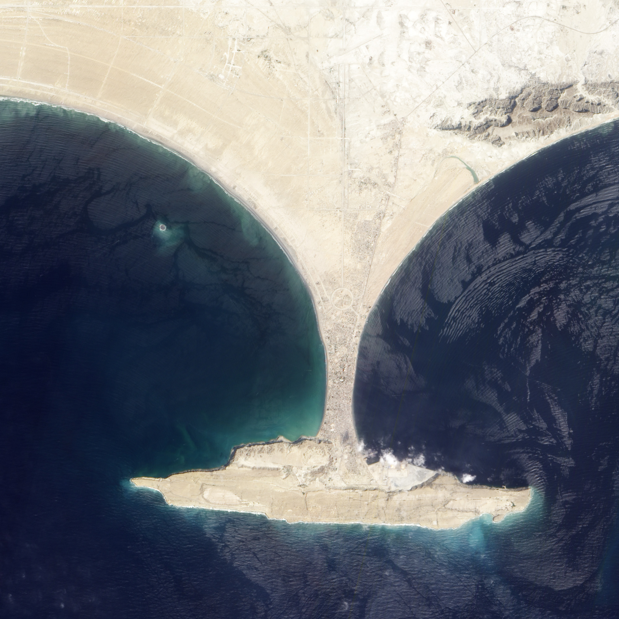
acquired September 26, 2013download large image (861 KB, JPEG, 2000x2000)
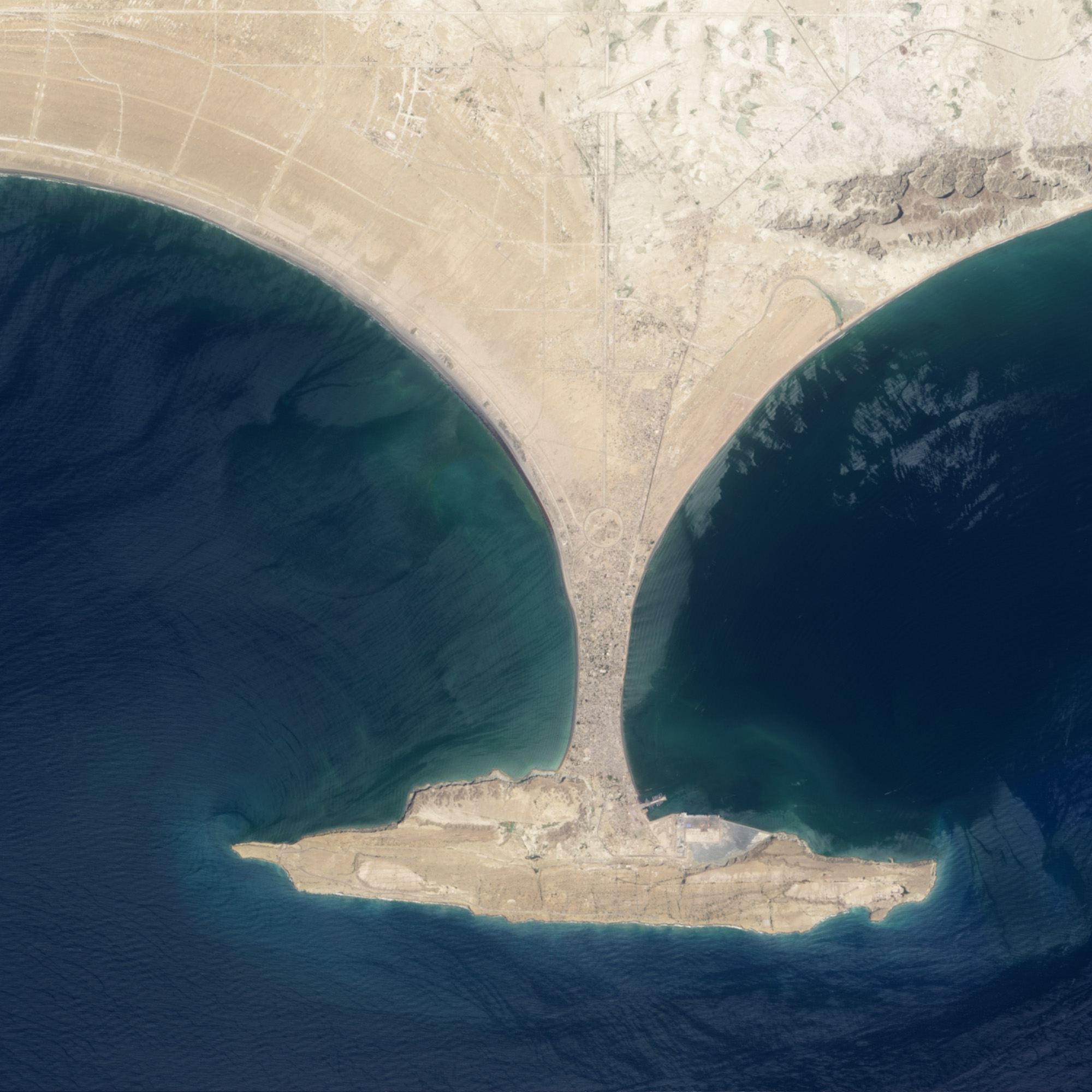
acquired April 17, 2013download large image (636 KB, JPEG, 2000x2000)

On September 24, 2013, a major strike-slip earthquake rattled western Pakistan, killing at least 350 people and leaving more than 100,000 homeless. The 7.7 magnitude quake struck the Baluchistan province of northwestern Pakistan. Amidst the destruction, a new island was created offshore in the Paddi Zirr (West Bay) near Gwadar, Pakistan.

On September 26, 2013, the Advanced Land Imager (ALI) on NASA’s Earth Observing-1 (EO-1) satellite captured the top image of that new island, which sits roughly one kilometer (0.6 miles) offshore. Likely a “mud volcano,” the island rose from the seafloor near Gwadar on September 24, shortly after the earthquake struck about 380 kilometers (230 miles) inland. The lower image, acquired by the Operational Land Imager on the Landsat 8 satellite, shows the same area on April 17, 2013.

In the satellite images, lighter shades of green and tan in the water reveal shallow seafloor or suspended sediment. The water depth around the new island is roughly 15 to 20 meters, according to marine geologist Asif Inam of Pakistan’s National Institute of Oceanography. “The floor in that area is generally flat, but the gradient in this area changes quite abruptly,” Inam said. The top image from ALI is also clear enough to show the parallel ripples of waves marching toward the shore.

The aerial photograph below from the National Institute of Oceanography provides a close-up of the landform, estimated to stretch 75 to 90 meters (250 to 300 feet) across and standing 15 to 20 meters (60 to 70 feet) above the water line. The surface is a mixture of mud, fine sand, and solid rock. Click on the downloadable video below the image for a first-hand view.

acquired September 26, 2013download animation (84 MB, MPEG)

“The island is really just a big pile of mud from the seafloor that got pushed up,” said Bill Barnhart, a geologist at the U.S. Geological Survey who studies earthquakes in Pakistan and Iran. “This area of the world seems to see so many of these features because the geology is correct for their formation. You need a shallow, buried layer of pressurized gas—methane, carbon dioxide, or something else—and fluids. When that layer becomes disturbed by seismic waves (like an earthquake), the gases and fluids become buoyant and rush to the surface, bringing the rock and mud with them.”

Inam asserted that the underground pressure in this case came from expanding natural gas. “The main driving force for the emergence of islands in this part of the world is highly pressurized methane gas, or gas hydrate. On the new island, there is a continuous escape of the highly flammable methane gas through a number of vents.”

Several of these islands have appeared off the 700-kilometer-long Makran coast in the past century noted Eric Fielding, a tectonics scientist at NASA’s Jet Propulsion Laboratory. He explained that the Makran coast is where the Arabian tectonic plate is pushed northward and downward to go underneath the Eurasian continental plate. The thick layer of mud and rock on the Arabian Plate is scraped off and has formed the land in southwestern Pakistan, southeastern Iran, and the shallow underwater area offshore.

“The Makran coast is not very populated and any such event may easily go unnoticed, so satellite images are extremely important,” Inam said. “Mud volcanoes and islands are a natural hazard and threat to navigation.”

The life of this island is likely to be short. That underground pocket of gas will cool, compress, or escape over time, allowing the crust to collapse and settle back down. Waves, storms, and tidal action from the Arabian Sea will also wash away the loose sand, soft clay, and mud. Barnhart says such islands usually last a few months to a year before sinking back below the water line.

References and Related Reading

NASA Earth Observatory image by Jesse Allen and Robert Simmon, using EO-1 ALI data from the NASA EO-1 team. Photograph and video courtesy of the National Institute of Oceanography, Pakistan. Caption by Michael Carlowicz, with interpretation help from William Barnhart, U.S. Geological Survey, Asif Inam, National Institute of Oceanography, Pakistan, and Eric Fielding, NASA’s Jet Propulsion Laboratory.

Instrument: EO-1 - ALI

jeudi 19 septembre 2013

Entre 10 000 et 20 000 îles pourraient être englouties par la montée des océans

L'île Surprise, du Récif d'Entrecasteaux, à 230 km au nord
de la Nouvelle-Calédonie, où les auteurs étudient le
fonctionnement des écosystèmes depuis plus d'une décennie.
Sa faible élévation la rend particulièrement sensible à la
montée du niveau des océans suite au réchauffement
climatique, avec une probabilité forte d'inondation
permanente totale d'ici la fin du siècle.
© Jean-Louis Chapuis
À l'horizon 2100, le niveau de la mer devrait augmenter de 1 à 3 mètres en raison du réchauffement climatique. Ceci aura un très fort impact sur les îles, leur faune, leur flore et leurs populations. Une équipe de chercheurs du laboratoire Ecologie, systématique et évolution (CNRS/Université Paris-Sud) a étudié les conséquences pour 1269 îles françaises à travers le monde. Leur modèle montre qu'entre 5% et 12% de ces îles risquent d'être totalement submergées dans le futur. A l'échelle de la planète, ils prédisent qu'environ 300 espèces endémiques insulaires risquent fortement de disparaître, tandis que des milliers d'autres verraient leur habitat se réduire de façon dramatique. Ces travaux ont été publiés dans les revues Global Ecology and Biogeography (août 2013) et Nature Conservation (septembre 2013).

Les scénarios les plus récents concernant le réchauffement climatique montrent que le niveau de la mer devrait s'élever, d'ici la fin du siècle, entre 1 et 3 mètres. Certains scénarios, qui prévoient une débâcle catastrophique des glaces du Groenland, tablent même sur une élévation atteignant 6 mètres. Cette hausse aura des conséquences dramatiques sur les populations, la flore et la faune établies sur la bande littorale.

Les chercheurs du laboratoire Ecologie, systématique et évolution se sont d'abord intéressés aux conséquences de la hausse du niveau de la mer sur les îles françaises. La France possède dans le monde entier 2050 îles de plus d'un hectare, et donc, susceptibles d'abriter des communautés animales et végétales.

Les scientifiques ont croisé les profils de relief de 1269 de ces îles avec les modèles d'élévation du niveau de la mer. Ceci, en tenant compte du fait que cette hausse ne sera pas homogène : la mer n'étant pas plate, certaines régions de l'océan s'élèveront plus que d'autres. Ils ont ainsi montré que, si le niveau de la mer augmente de 1 mètre seulement en moyenne, la France perdrait 6% de ses îles (et 12% pour 3 mètres d'élévation). La Polynésie française et la Nouvelle Calédonie seraient les régions les plus affectées : 2/3 des îles qui seraient submergées appartiennent à ces archipels. La France possède des îles dans tous les océans, sous toutes les latitudes et de tous types géologiques et écologiques. De ce fait, les chercheurs pensent que si leurs résultats sont extrapolés aux 180 000 îles du monde entier, la planète pourrait perdre au cours de ce siècle entre 10 000 et 20 000 îles.

Les chercheurs se sont ensuite intéressés aux pertes de biodiversité dues à cette hausse du niveau de la mer, et notamment dans certains points chauds de biodiversité comme la Méditerranée, les Philippines ou la Nouvelle Calédonie. En effet, 20% de la biodiversité mondiale se situe dans les îles. Celles-ci ont la particularité d'abriter une très grande proportion d'espèces endémiques.

Les Philippines, l'Indonésie et les Caraïbes sont les zones les plus vulnérables : au moins 300 espèces endémiques, en majorité des plantes, y sont gravement menacées par l'élévation du niveau des mers. Ce chiffre constitue l'estimation la plus basse. En effet, les chercheurs n'ont considéré que les espèces dont l'aire de répartition serait totalement immergée à l'horizon 2100. Ils n'ont pas considéré les espèces perdant 70, 80 voire 90% de leur territoire, ni l'addition d'autres facteurs comme l'érosion latérale ou les marées exceptionnelles qui peuvent rendre inaptes à la survie de nombreuses espèces une large bande du littoral, ni tenu compte des événements catastrophiques comme les cyclones.

Ces travaux montrent à quel point l'élévation du niveau de la mer est une nouvelle menace qui pèse sur la biodiversité des écosystèmes insulaires. De ce fait, les politiques de conservation ou de sauvegarde d'espèces en danger doivent aussi prendre en compte les conséquences de ce processus inexorable.

Références
Auteur

Centre National de la Recherche Scientifique

Les opinions exprimées dans cet article n'engagent que leur auteur et ne reflètent pas nécessairement celles de notre-planete.info

18 septembre 2013, 14 h 11